Kihancha elevation
Kihancha (Migori), Kenya elevation is 1496 meters and Kihancha elevation in feet is 4908 ft above sea level [src 1]. Kihancha is a populated place (feature code) with elevation that is 150 meters (492 ft) bigger than average city elevation in Kenya.
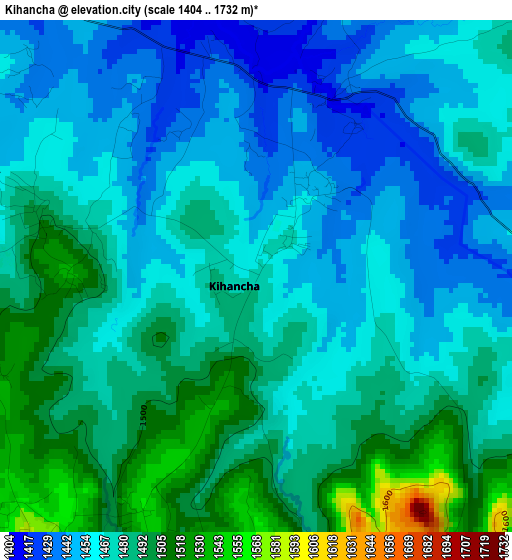
Below is the Elevation map of Kihancha, which displays elevation range with different colors. Scale of the first map is from 1404 to 1732 m (4606 to 5682 ft) with average elevation of 1473.5 meters (=4834 ft) [note 1]
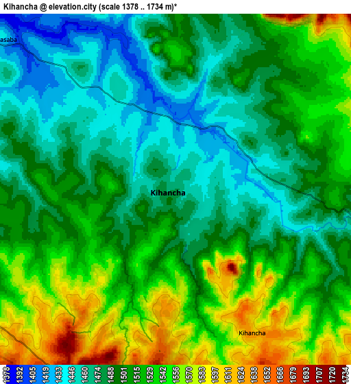
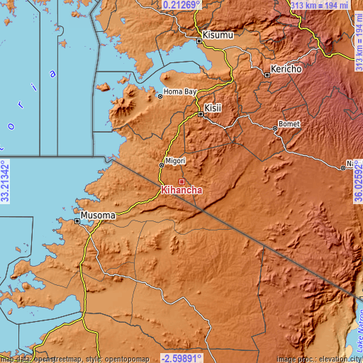
These maps also provides idea of topography and contour of this city, they are displayed at different zoom levels. More info about maps, scale and edge coordinates you can find below images.
| \ | Map #1 | Map #2 | Topo.Map |
| Scale [m] | 1404..1732 m | 1378..1734 m | × |
| Scale [ft] | 4606..5682 ft | 4521..5689 ft | × |
| Average | 1473.5 m = 4834 ft | 1506.9 m = 4944 ft | × |
| Width | 9.77 km = 6.1 mi | 19.54 km = 12.1 mi | 312.6 km = 194.2 mi |
| Height | 9.77 km = 6.1 mi | 19.54 km = 12.1 mi | 312.7 km = 194.3 mi |
| ↑Max Latitude | -1.149534° | -1.105597° | 0.21269° |
| Latitude at center | -1.19347° | -1.19347° | -1.19347° |
| ↓Min Latitude | -1.237405° | -1.28134° | -2.59891° |
| ← Min Longitude | 34.575725° | 34.531779° | 33.21342° |
| Longitude center | 34.61967° | 34.61967° | 34.61967° |
| →Max Longitude | 34.663615° | 34.707561° | 36.02592° |
Nearby cities:
Cities around Kihancha sort by population:
• Homa Bay elevation 1165 m
76.2 km,  346°
346°
• Kericho 2002 m
117.8 km,  38°
38°
• Migori 1382 m
21.8 km,  311°
311°
• Kisii 1686 m
59.2 km,  16°
16°
• Oyugis 1437 m
77 km,  9°
9°
• Nyamira 2000 m
78.4 km,  26°
26°
• Ahero 1153 m
118.2 km, 16°
• Sotik Post 1959 m
92.4 km,  60°
60°
• Keroka 2126 m
59 km, 38°
• Litein 1940 m
92.9 km, 43°
• Sotik 1779 m
78.2 km, 44°
• Ogembo 1661 m
45.2 km, 15°
Multilingual:
 En español:
Kihancha elevación 1496 m.
 En France:
Kihancha élévation 1496 m.
 Auf Deutsch:
Kihancha höhe über dem Meeresspiegel ist 1496 m.

Sources and notes:
- [note 1] Map square and city borders are not equal. Map elevation data is calculated only from area inside that square.
- [src 1] Elevation data from geonames database provided with same terms of usage.
- [src 2] The elevation map of Kihancha is generated using elevation data from NASA's 3 arcsec (90m) resolution SRTM data.
- [src 3] Base (background) map © OpenStreetMap contributors tiles are generated by Geofabrik and OpenTopoMap.
Copyright & License:
This Kihancha Elevation Map is licensed under CC BY-SA. You may reuse any part from this page, if you give a proper credit by linking to this URL:
 More info on terms of use page.