Fujiyoshida elevation
Fujiyoshida (Yamanashi, Fuji-yoshida Shi), Japan elevation is 1055 meters and Fujiyoshida elevation in feet is 3461 ft above sea level [src 1]. Fujiyoshida is a populated place (feature code) with elevation that is 970 meters (3182 ft) bigger than average city elevation in Japan.
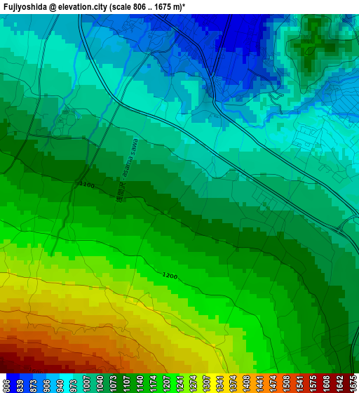
Below is the Elevation map of Fujiyoshida, which displays elevation range with different colors. Scale of the first map is from 806 to 1675 m (2644 to 5495 ft) with average elevation of 1095.2 meters (=3593 ft) [note 1]
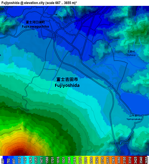
These maps also provides idea of topography and contour of this city, they are displayed at different zoom levels. More info about maps, scale and edge coordinates you can find below images.
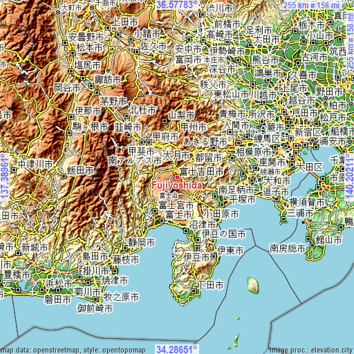
| \ | Map #1 | Map #2 | Topo.Map |
| Scale [m] | 806..1675 m | 667..3655 m | × |
| Scale [ft] | 2644..5495 ft | 2188..11991 ft | × |
| Average | 1095.2 m = 3593 ft | 1215.8 m = 3989 ft | × |
| Width | 7.96 km = 4.9 mi | 15.92 km = 9.9 mi | 254.8 km = 158.3 mi |
| Height | 7.96 km = 4.9 mi | 15.92 km = 9.9 mi | 254.8 km = 158.3 mi |
| ↑Max Latitude | 35.476115° | 35.511894° | 36.57783° |
| Latitude at center | 35.44032° | 35.44032° | 35.44032° |
| ↓Min Latitude | 35.404509° | 35.368682° | 34.28651° |
| ← Min Longitude | 138.751915° | 138.707969° | 137.38961° |
| Longitude center | 138.79586° | 138.79586° | 138.79586° |
| →Max Longitude | 138.839805° | 138.883751° | 140.20211° |
Nearby cities:
Cities around Fujiyoshida sort by population:
• Fujinomiya elevation 116 m
29.7 km,  213°
213°
• Gotenba 446 m
19 km,  135°
135°
• Ōtsuki 360 m
25.5 km,  39°
39°
• Isawa 269 m
27.6 km,  327°
327°
• Enzan 393 m
29.4 km,  348°
348°
• Fujikawaguchiko 1086 m
11.2 km,  299°
299°
• Susono 133 m
31.3 km,  161°
161°
• Yamanashi 321 m
27.2 km,  341°
341°
• Yamakita 144 m
27.1 km,  108°
108°
• Fuefuki 268 m
25.9 km, 326°
• Tsuru 596 m
15.7 km, 40°
• Fuji-yoshida 777 m
5.1 km,  15°
15°
Multilingual:
 En español:
Fujiyoshida elevación 1055 m.
 En France:
Fujiyoshida élévation 1055 m.
 Auf Deutsch:
Fujiyoshida höhe über dem Meeresspiegel ist 1055 m.

Sources and notes:
- [note 1] Map square and city borders are not equal. Map elevation data is calculated only from area inside that square.
- [src 1] Elevation data from geonames database provided with same terms of usage.
- [src 2] The elevation map of Fujiyoshida is generated using elevation data from NASA's 3 arcsec (90m) resolution SRTM data.
- [src 3] Base (background) map © OpenStreetMap contributors tiles are generated by Geofabrik and OpenTopoMap.
Copyright & License:
This Fujiyoshida Elevation Map is licensed under CC BY-SA. You may reuse any part from this page, if you give a proper credit by linking to this URL:
 More info on terms of use page.