Isawa elevation
Isawa (Yamanashi, Fuefuki-shi), Japan elevation is 269 meters and Isawa elevation in feet is 883 ft above sea level [src 1]. Isawa is a populated place (feature code) with elevation that is 184 meters (604 ft) bigger than average city elevation in Japan.
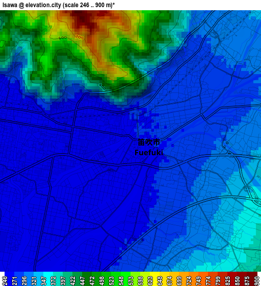
Below is the Elevation map of Isawa, which displays elevation range with different colors. Scale of the first map is from 246 to 900 m (807 to 2953 ft) with average elevation of 329.4 meters (=1081 ft) [note 1]
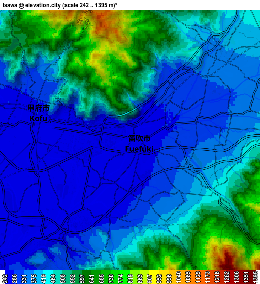
These maps also provides idea of topography and contour of this city, they are displayed at different zoom levels. More info about maps, scale and edge coordinates you can find below images.
| \ | Map #1 | Map #2 | Topo.Map |
| Scale [m] | 246..900 m | 242..1395 m | × |
| Scale [ft] | 807..2953 ft | 794..4577 ft | × |
| Average | 329.4 m = 1081 ft | 435.1 m = 1427 ft | × |
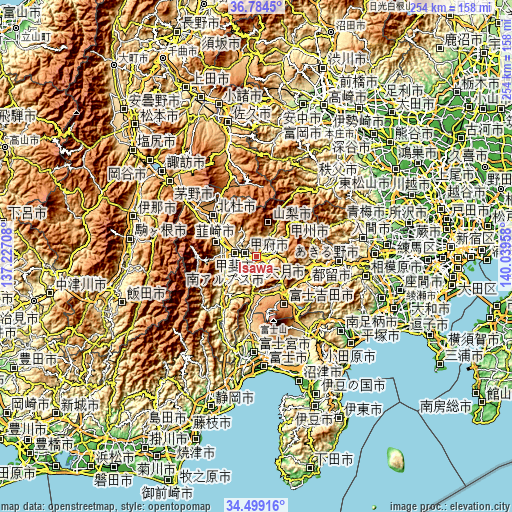
| Width | 7.94 km = 4.9 mi | 15.88 km = 9.9 mi | 254.1 km = 157.9 mi |
| Height | 7.94 km = 4.9 mi | 15.88 km = 9.9 mi | 254.1 km = 157.9 mi |
| ↑Max Latitude | 35.685702° | 35.721387° | 36.7845° |
| Latitude at center | 35.65° | 35.65° | 35.65° |
| ↓Min Latitude | 35.614282° | 35.578549° | 34.49916° |
| ← Min Longitude | 138.589385° | 138.545439° | 137.22708° |
| Longitude center | 138.63333° | 138.63333° | 138.63333° |
| →Max Longitude | 138.677275° | 138.721221° | 140.03958° |
Nearby cities:
Cities around Isawa sort by population:
• Kōfu elevation 275 m
6.3 km,  287°
287°
• Ryūō 288 m
12 km,  270°
270°
• Nirasaki 349 m
17.5 km, 288°
• Enzan 393 m
10.6 km,  58°
58°
• Fujikawaguchiko 1086 m
18.5 km,  164°
164°
• Minami-Alps 298 m
15.8 km,  256°
256°
• Kōshū 635 m
14.9 km, 56°
• Chūō 249 m
13.3 km,  242°
242°
• Kai 340 m
11.8 km, 289°
• Kofu 459 m
6.7 km,  322°
322°
• Yamanashi 321 m
6.3 km,  67°
67°
• Fuefuki 268 m
1.7 km, 164°
Multilingual:
 En español:
Isawa elevación 269 m.
 En France:
Isawa élévation 269 m.


Sources and notes:
- [note 1] Map square and city borders are not equal. Map elevation data is calculated only from area inside that square.
- [src 1] Elevation data from geonames database provided with same terms of usage.
- [src 2] The elevation map of Isawa is generated using elevation data from NASA's 3 arcsec (90m) resolution SRTM data.
- [src 3] Base (background) map © OpenStreetMap contributors tiles are generated by Geofabrik and OpenTopoMap.
Copyright & License:
This Isawa Elevation Map is licensed under CC BY-SA. You may reuse any part from this page, if you give a proper credit by linking to this URL:
 More info on terms of use page.