Kamigyō-ku elevation
Kamigyō-ku (Kyoto, Kyōto-shi), Japan elevation is 61 meters and Kamigyō-ku elevation in feet is 200 ft above sea level [src 1]. Kamigyō-ku is a seat of a third-order administrative division (feature code) with elevation that is 24 meters (79 ft) smaller than average city elevation in Japan.
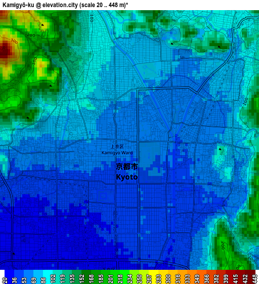
Below is the Elevation map of Kamigyō-ku, which displays elevation range with different colors. Scale of the first map is from 20 to 448 m (66 to 1470 ft) with average elevation of 83.7 meters (=275 ft) [note 1]
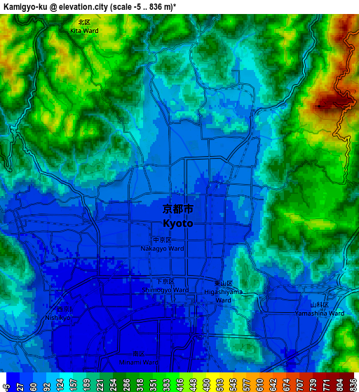
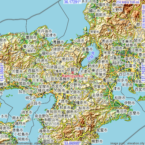
These maps also provides idea of topography and contour of this city, they are displayed at different zoom levels. More info about maps, scale and edge coordinates you can find below images.
| \ | Map #1 | Map #2 | Topo.Map |
| Scale [m] | 20..448 m | -5..836 m | × |
| Scale [ft] | 66..1470 ft | -16..2743 ft | × |
| Average | 83.7 m = 275 ft | 177.4 m = 582 ft | × |
| Width | 8 km = 5 mi | 16 km = 9.9 mi | 256.1 km = 159.1 mi |
| Height | 8 km = 5 mi | 16 km = 9.9 mi | 256.1 km = 159.1 mi |
| ↑Max Latitude | 35.065517° | 35.101478° | 36.17291° |
| Latitude at center | 35.02954° | 35.02954° | 35.02954° |
| ↓Min Latitude | 34.993547° | 34.957539° | 33.86995° |
| ← Min Longitude | 135.712715° | 135.668769° | 134.35041° |
| Longitude center | 135.75666° | 135.75666° | 135.75666° |
| →Max Longitude | 135.800605° | 135.844551° | 137.16291° |
Nearby cities:
Cities around Kamigyō-ku sort by population:
• Kyoto elevation 50 m
1 km,  195°
195°
• Ōtsu 131 m
10.5 km,  108°
108°
• Uji 23 m
16 km,  164°
164°
• Kusatsu 102 m
19.2 km,  94°
94°
• Kameoka 129 m
16.1 km,  258°
258°
• Yawata 17 m
18.4 km, 195°
• Moriyama 92 m
21 km,  78°
78°
• Mukō 19 m
8.6 km,  213°
213°
• Arashiyama 36 m
7.4 km, 257°
• Kitahama 97 m
21.1 km,  43°
43°
• Jōyō 88 m
21.1 km,  167°
167°
• Nagaoka 30 m
12.4 km, 208°
Multilingual:
 En español:
Kamigyō-ku elevación 61 m.
 En France:
Kamigyō-ku élévation 61 m.
 Auf Deutsch:
Kamigyō-ku höhe über dem Meeresspiegel ist 61 m.

Sources and notes:
- [note 1] Map square and city borders are not equal. Map elevation data is calculated only from area inside that square.
- [src 1] Elevation data from geonames database provided with same terms of usage.
- [src 2] The elevation map of Kamigyō-ku is generated using elevation data from NASA's 3 arcsec (90m) resolution SRTM data.
- [src 3] Base (background) map © OpenStreetMap contributors tiles are generated by Geofabrik and OpenTopoMap.
Copyright & License:
This Kamigyō-ku Elevation Map is licensed under CC BY-SA. You may reuse any part from this page, if you give a proper credit by linking to this URL:
 More info on terms of use page.