Kusatsu elevation
Kusatsu (Shiga, Kusatsu-shi), Japan elevation is 102 meters and Kusatsu elevation in feet is 335 ft above sea level [src 1]. Kusatsu is a seat of a second-order administrative division (feature code) with elevation that is 17 meters (56 ft) bigger than average city elevation in Japan.
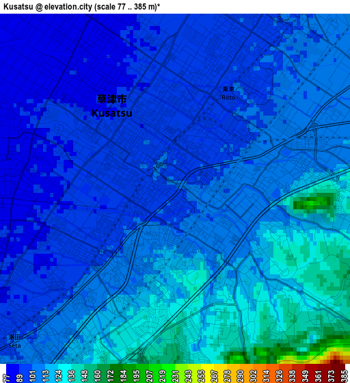
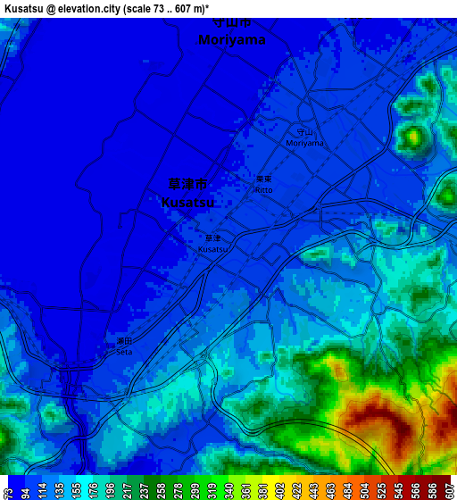
Below is the Elevation map of Kusatsu, which displays elevation range with different colors. Scale of the first map is from 77 to 385 m (253 to 1263 ft) with average elevation of 107.1 meters (=351 ft) [note 1]
These maps also provides idea of topography and contour of this city, they are displayed at different zoom levels. More info about maps, scale and edge coordinates you can find below images.
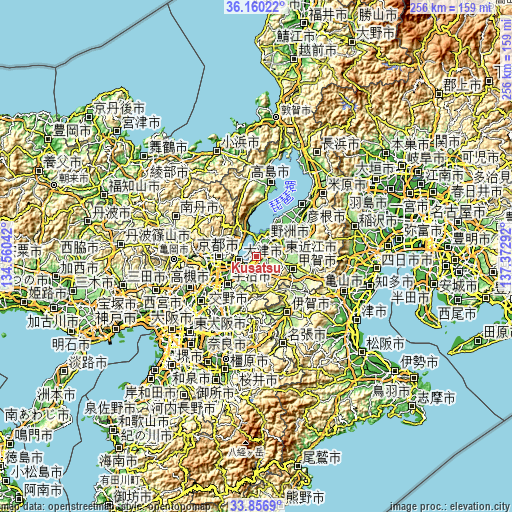
| \ | Map #1 | Map #2 | Topo.Map |
| Scale [m] | 77..385 m | 73..607 m | × |
| Scale [ft] | 253..1263 ft | 240..1991 ft | × |
| Average | 107.1 m = 351 ft | 137.8 m = 452 ft | × |
| Width | 8 km = 5 mi | 16.01 km = 9.9 mi | 256.1 km = 159.1 mi |
| Height | 8 km = 5 mi | 16.01 km = 9.9 mi | 256.1 km = 159.1 mi |
| ↑Max Latitude | 35.052653° | 35.088619° | 36.16022° |
| Latitude at center | 35.01667° | 35.01667° | 35.01667° |
| ↓Min Latitude | 34.980672° | 34.944657° | 33.8569° |
| ← Min Longitude | 135.922725° | 135.878779° | 134.56042° |
| Longitude center | 135.96667° | 135.96667° | 135.96667° |
| →Max Longitude | 136.010615° | 136.054561° | 137.37292° |
Nearby cities:
Cities around Kusatsu sort by population:
• Kyoto elevation 50 m
19.4 km,  271°
271°
• Ōtsu 131 m
9.3 km,  258°
258°
• Uji 23 m
20.5 km,  226°
226°
• Kamigyō-ku 61 m
19.2 km, 274°
• Ōmihachiman 91 m
17.2 km,  43°
43°
• Moriyama 92 m
5.8 km,  15°
15°
• Minakuchichō-matoba 171 m
19 km,  106°
106°
• Kitahama 97 m
17.3 km,  344°
344°
• Kōka 170 m
17.8 km,  103°
103°
• Konan 137 m
12 km, 99°
• Yasu 87 m
10.4 km,  26°
26°
• Rittō 107 m
3.2 km,  68°
68°
Multilingual:
 En español:
Kusatsu elevación 102 m.
 En France:
Kusatsu élévation 102 m.


Sources and notes:
- [note 1] Map square and city borders are not equal. Map elevation data is calculated only from area inside that square.
- [src 1] Elevation data from geonames database provided with same terms of usage.
- [src 2] The elevation map of Kusatsu is generated using elevation data from NASA's 3 arcsec (90m) resolution SRTM data.
- [src 3] Base (background) map © OpenStreetMap contributors tiles are generated by Geofabrik and OpenTopoMap.
Copyright & License:
This Kusatsu Elevation Map is licensed under CC BY-SA. You may reuse any part from this page, if you give a proper credit by linking to this URL:
 More info on terms of use page.