Kakunodatemachi elevation
Kakunodatemachi (Akita, Semboku-shi), Japan elevation is 70 meters and Kakunodatemachi elevation in feet is 230 ft above sea level [src 1]. Kakunodatemachi is a populated place (feature code) with elevation that is 15 meters (49 ft) smaller than average city elevation in Japan.
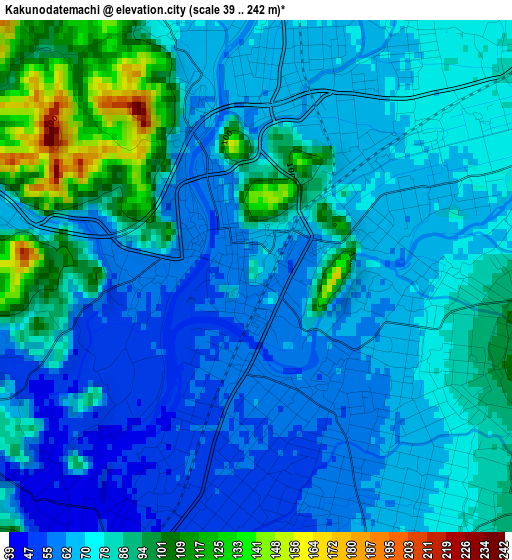
Below is the Elevation map of Kakunodatemachi, which displays elevation range with different colors. Scale of the first map is from 39 to 242 m (128 to 794 ft) with average elevation of 75.9 meters (=249 ft) [note 1]
These maps also provides idea of topography and contour of this city, they are displayed at different zoom levels. More info about maps, scale and edge coordinates you can find below images.
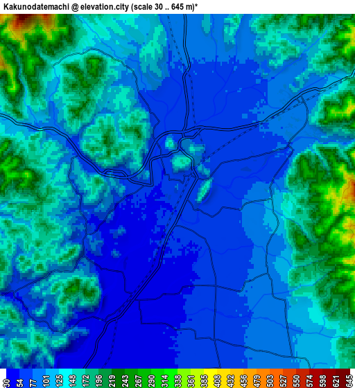
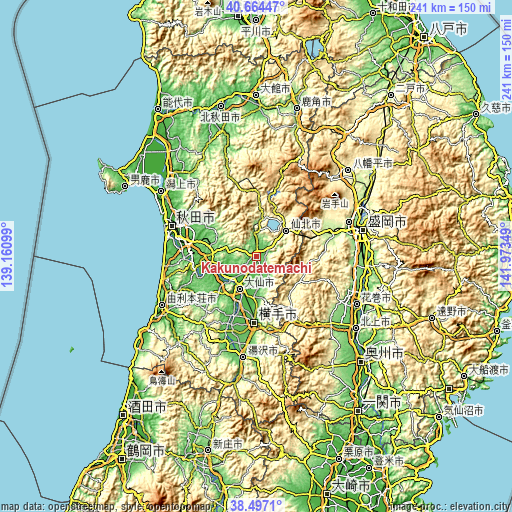
| \ | Map #1 | Map #2 | Topo.Map |
| Scale [m] | 39..242 m | 30..645 m | × |
| Scale [ft] | 128..794 ft | 98..2116 ft | × |
| Average | 75.9 m = 249 ft | 118.8 m = 390 ft | × |
| Width | 7.53 km = 4.7 mi | 15.06 km = 9.4 mi | 241 km = 149.8 mi |
| Height | 7.53 km = 4.7 mi | 15.06 km = 9.4 mi | 241 km = 149.8 mi |
| ↑Max Latitude | 39.623117° | 39.656958° | 40.66447° |
| Latitude at center | 39.58926° | 39.58926° | 39.58926° |
| ↓Min Latitude | 39.555386° | 39.521496° | 38.4971° |
| ← Min Longitude | 140.523295° | 140.479349° | 139.16099° |
| Longitude center | 140.56724° | 140.56724° | 140.56724° |
| →Max Longitude | 140.611185° | 140.655131° | 141.97349° |
Nearby cities:
Cities around Kakunodatemachi sort by population:
• Akita elevation 14 m
41.1 km,  290°
290°
• Morioka 138 m
51.4 km,  76°
76°
• Kitakami 63 m
58.2 km,  125°
125°
• Hanamaki 77 m
52.4 km,  115°
115°
• Yokote 61 m
30.3 km,  182°
182°
• Ōmagari 28 m
17.1 km,  204°
204°
• Yuzawa 100 m
47.3 km,  187°
187°
• Shizukuishi 192 m
37.6 km,  71°
71°
• Takizawa 262 m
54 km,  63°
63°
• Yurihonjō 4 m
49 km,  243°
243°
• Semboku 389 m
20.3 km,  48°
48°
• Daisen 22 m
17.8 km, 202°
Multilingual:
 En español:
Kakunodatemachi elevación 70 m.
 En France:
Kakunodatemachi élévation 70 m.
 Auf Deutsch:
Kakunodatemachi höhe über dem Meeresspiegel ist 70 m.

Sources and notes:
- [note 1] Map square and city borders are not equal. Map elevation data is calculated only from area inside that square.
- [src 1] Elevation data from geonames database provided with same terms of usage.
- [src 2] The elevation map of Kakunodatemachi is generated using elevation data from NASA's 3 arcsec (90m) resolution SRTM data.
- [src 3] Base (background) map © OpenStreetMap contributors tiles are generated by Geofabrik and OpenTopoMap.
Copyright & License:
This Kakunodatemachi Elevation Map is licensed under CC BY-SA. You may reuse any part from this page, if you give a proper credit by linking to this URL:
 More info on terms of use page.