Marumori elevation
Marumori (Miyagi, Igu-gun), Japan elevation is 22 meters and Marumori elevation in feet is 72 ft above sea level [src 1]. Marumori is a populated place (feature code) with elevation that is 63 meters (207 ft) smaller than average city elevation in Japan.
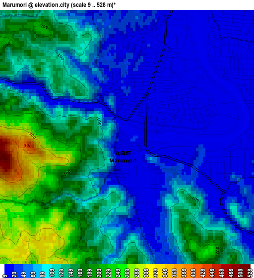
Below is the Elevation map of Marumori, which displays elevation range with different colors. Scale of the first map is from 9 to 528 m (30 to 1732 ft) with average elevation of 101.1 meters (=332 ft) [note 1]
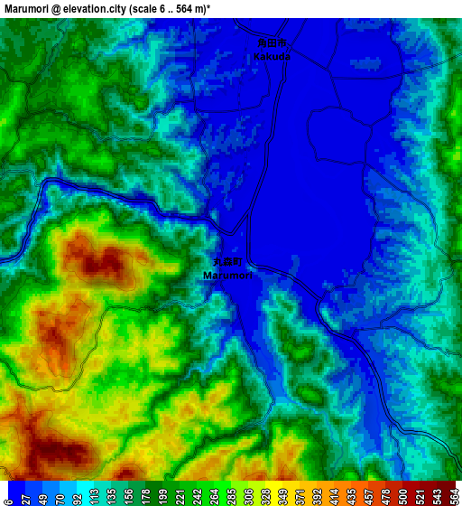
These maps also provides idea of topography and contour of this city, they are displayed at different zoom levels. More info about maps, scale and edge coordinates you can find below images.
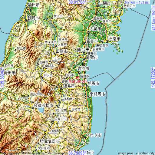
| \ | Map #1 | Map #2 | Topo.Map |
| Scale [m] | 9..528 m | 6..564 m | × |
| Scale [ft] | 30..1732 ft | 20..1850 ft | × |
| Average | 101.1 m = 332 ft | 151.5 m = 497 ft | × |
| Width | 7.71 km = 4.8 mi | 15.42 km = 9.6 mi | 246.7 km = 153.3 mi |
| Height | 7.71 km = 4.8 mi | 15.42 km = 9.6 mi | 246.7 km = 153.3 mi |
| ↑Max Latitude | 37.951331° | 37.985975° | 39.01768° |
| Latitude at center | 37.91667° | 37.91667° | 37.91667° |
| ↓Min Latitude | 37.881993° | 37.8473° | 36.79893° |
| ← Min Longitude | 140.722725° | 140.678779° | 139.36042° |
| Longitude center | 140.76667° | 140.76667° | 140.76667° |
| →Max Longitude | 140.810615° | 140.854561° | 142.17292° |
Nearby cities:
Cities around Marumori sort by population:
• Fukushima elevation 77 m
32.2 km,  234°
234°
• Iwanuma 5 m
22.4 km,  21°
21°
• Shiroishi 57 m
16.2 km,  306°
306°
• Watari 10 m
15.1 km,  29°
29°
• Kakuda 12 m
6.4 km,  4°
4°
• Hobaramachi 51 m
22 km,  239°
239°
• Ōkawara 20 m
15.1 km,  348°
348°
• Yanagawamachi-saiwaichō 44 m
16.4 km, 243°
• Minami-Sōma 27 m
37 km,  149°
149°
• Natori-shi 9 m
29.6 km, 20°
• Date 58 m
25.9 km, 244°
• Sōma 9 m
19.8 km,  133°
133°
Multilingual:
 En español:
Marumori elevación 22 m.
 En France:
Marumori élévation 22 m.


Sources and notes:
- [note 1] Map square and city borders are not equal. Map elevation data is calculated only from area inside that square.
- [src 1] Elevation data from geonames database provided with same terms of usage.
- [src 2] The elevation map of Marumori is generated using elevation data from NASA's 3 arcsec (90m) resolution SRTM data.
- [src 3] Base (background) map © OpenStreetMap contributors tiles are generated by Geofabrik and OpenTopoMap.
Copyright & License:
This Marumori Elevation Map is licensed under CC BY-SA. You may reuse any part from this page, if you give a proper credit by linking to this URL:
 More info on terms of use page.