Shiroishi elevation
Shiroishi (Miyagi, Shiroishi Shi), Japan elevation is 57 meters and Shiroishi elevation in feet is 187 ft above sea level [src 1]. Shiroishi is a seat of a second-order administrative division (feature code) with elevation that is 28 meters (92 ft) smaller than average city elevation in Japan.
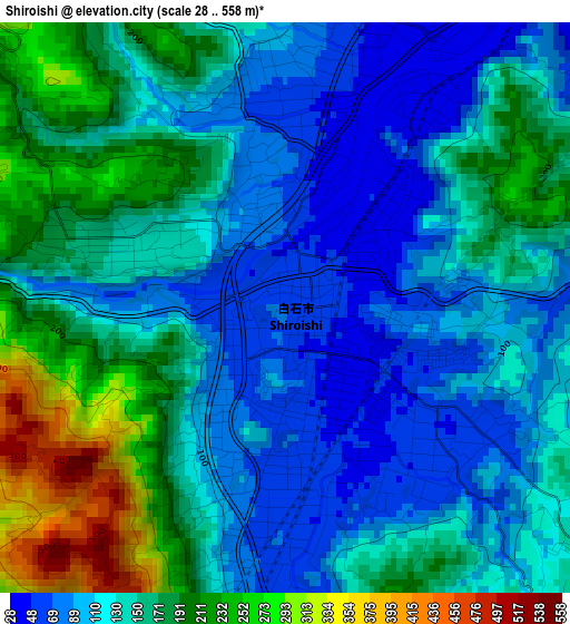
Below is the Elevation map of Shiroishi, which displays elevation range with different colors. Scale of the first map is from 28 to 558 m (92 to 1831 ft) with average elevation of 142.4 meters (=467 ft) [note 1]
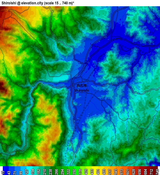
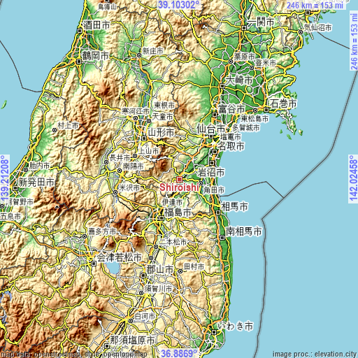
These maps also provides idea of topography and contour of this city, they are displayed at different zoom levels. More info about maps, scale and edge coordinates you can find below images.
| \ | Map #1 | Map #2 | Topo.Map |
| Scale [m] | 28..558 m | 15..740 m | × |
| Scale [ft] | 92..1831 ft | 49..2428 ft | × |
| Average | 142.4 m = 467 ft | 218.5 m = 717 ft | × |
| Width | 7.7 km = 4.8 mi | 15.4 km = 9.6 mi | 246.4 km = 153.1 mi |
| Height | 7.7 km = 4.8 mi | 15.4 km = 9.6 mi | 246.4 km = 153.1 mi |
| ↑Max Latitude | 38.03795° | 38.072553° | 39.10302° |
| Latitude at center | 38.00333° | 38.00333° | 38.00333° |
| ↓Min Latitude | 37.968694° | 37.934042° | 36.8869° |
| ← Min Longitude | 140.574385° | 140.530439° | 139.21208° |
| Longitude center | 140.61833° | 140.61833° | 140.61833° |
| →Max Longitude | 140.662275° | 140.706221° | 142.02458° |
Nearby cities:
Cities around Shiroishi sort by population:
• Fukushima elevation 77 m
31.2 km,  205°
205°
• Yamagata 321 m
33.7 km,  319°
319°
• Iwanuma 5 m
23.9 km,  61°
61°
• Watari 10 m
20.7 km,  80°
80°
• Kaminoyama 177 m
34.5 km,  299°
299°
• Kakuda 12 m
13.8 km,  103°
103°
• Hobaramachi 51 m
21.6 km,  196°
196°
• Ōkawara 20 m
11.4 km, 62°
• Yanagawamachi-saiwaichō 44 m
17.1 km,  185°
185°
• Marumori 22 m
16.2 km,  126°
126°
• Natori-shi 9 m
29.5 km,  51°
51°
• Date 58 m
23.2 km, 206°
Multilingual:
 En español:
Shiroishi elevación 57 m.
 En France:
Shiroishi élévation 57 m.
 Auf Deutsch:
Shiroishi höhe über dem Meeresspiegel ist 57 m.

Sources and notes:
- [note 1] Map square and city borders are not equal. Map elevation data is calculated only from area inside that square.
- [src 1] Elevation data from geonames database provided with same terms of usage.
- [src 2] The elevation map of Shiroishi is generated using elevation data from NASA's 3 arcsec (90m) resolution SRTM data.
- [src 3] Base (background) map © OpenStreetMap contributors tiles are generated by Geofabrik and OpenTopoMap.
Copyright & License:
This Shiroishi Elevation Map is licensed under CC BY-SA. You may reuse any part from this page, if you give a proper credit by linking to this URL:
 More info on terms of use page.