Mizusawa elevation
Mizusawa (Iwate, Ōshū-shi), Japan elevation is 64 meters and Mizusawa elevation in feet is 210 ft above sea level [src 1]. Mizusawa is a populated place (feature code) with elevation that is 21 meters (69 ft) smaller than average city elevation in Japan.
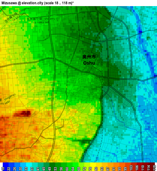
Below is the Elevation map of Mizusawa, which displays elevation range with different colors. Scale of the first map is from 18 to 118 m (59 to 387 ft) with average elevation of 58.6 meters (=192 ft) [note 1]
These maps also provides idea of topography and contour of this city, they are displayed at different zoom levels. More info about maps, scale and edge coordinates you can find below images.
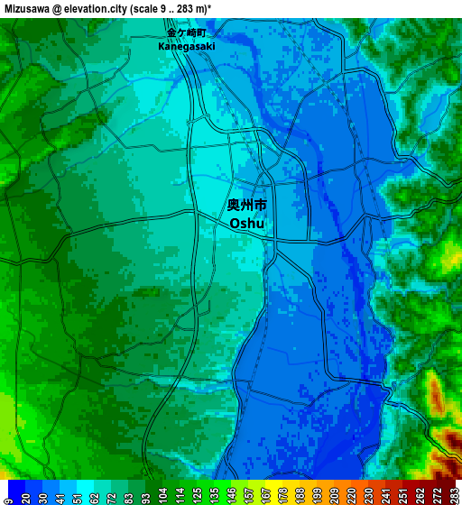
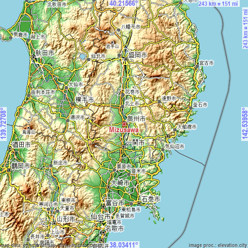
| \ | Map #1 | Map #2 | Topo.Map |
| Scale [m] | 18..118 m | 9..283 m | × |
| Scale [ft] | 59..387 ft | 30..928 ft | × |
| Average | 58.6 m = 192 ft | 73 m = 240 ft | × |
| Width | 7.58 km = 4.7 mi | 15.16 km = 9.4 mi | 242.6 km = 150.7 mi |
| Height | 7.58 km = 4.7 mi | 15.16 km = 9.4 mi | 242.6 km = 150.7 mi |
| ↑Max Latitude | 39.167409° | 39.201472° | 40.21566° |
| Latitude at center | 39.13333° | 39.13333° | 39.13333° |
| ↓Min Latitude | 39.099234° | 39.065122° | 38.03411° |
| ← Min Longitude | 141.089385° | 141.045439° | 139.72708° |
| Longitude center | 141.13333° | 141.13333° | 141.13333° |
| →Max Longitude | 141.177275° | 141.221221° | 142.53958° |
Nearby cities:
Cities around Mizusawa sort by population:
• Kitakami elevation 63 m
16.7 km,  355°
355°
• Hanamaki 77 m
27.8 km, 357°
• Ichinoseki 30 m
24.1 km,  180°
180°
• Yokote 61 m
54.2 km,  292°
292°
• Ōfunato 7 m
50.8 km,  97°
97°
• Yuzawa 100 m
54.7 km,  273°
273°
• Tōno 328 m
40 km,  59°
59°
• Tome 6 m
47.2 km, 177°
• Kesennuma 14 m
46.2 km,  123°
123°
• Kurihara 42 m
44.2 km,  195°
195°
• Rikuzentakata 9 m
41.7 km, 104°
• Ōshū 36 m
3.1 km,  77°
77°
Multilingual:
 En español:
Mizusawa elevación 64 m.
 En France:
Mizusawa élévation 64 m.


Sources and notes:
- [note 1] Map square and city borders are not equal. Map elevation data is calculated only from area inside that square.
- [src 1] Elevation data from geonames database provided with same terms of usage.
- [src 2] The elevation map of Mizusawa is generated using elevation data from NASA's 3 arcsec (90m) resolution SRTM data.
- [src 3] Base (background) map © OpenStreetMap contributors tiles are generated by Geofabrik and OpenTopoMap.
Copyright & License:
This Mizusawa Elevation Map is licensed under CC BY-SA. You may reuse any part from this page, if you give a proper credit by linking to this URL:
 More info on terms of use page.