Sagae elevation
Sagae (Yamagata, Sagae-shi), Japan elevation is 102 meters and Sagae elevation in feet is 335 ft above sea level [src 1]. Sagae is a seat of a second-order administrative division (feature code) with elevation that is 17 meters (56 ft) bigger than average city elevation in Japan.
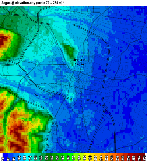
Below is the Elevation map of Sagae, which displays elevation range with different colors. Scale of the first map is from 79 to 274 m (259 to 899 ft) with average elevation of 112.1 meters (=368 ft) [note 1]
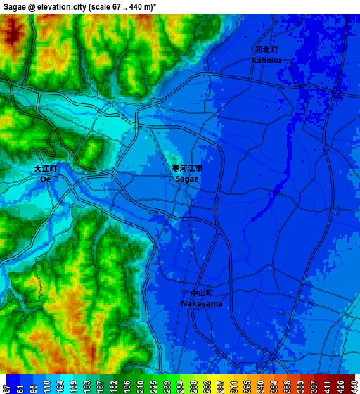
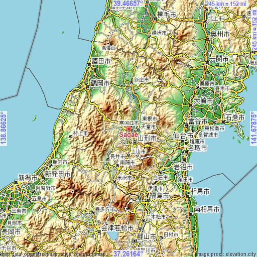
These maps also provides idea of topography and contour of this city, they are displayed at different zoom levels. More info about maps, scale and edge coordinates you can find below images.
| \ | Map #1 | Map #2 | Topo.Map |
| Scale [m] | 79..274 m | 67..440 m | × |
| Scale [ft] | 259..899 ft | 220..1444 ft | × |
| Average | 112.1 m = 368 ft | 142.6 m = 468 ft | × |
| Width | 7.66 km = 4.8 mi | 15.32 km = 9.5 mi | 245.2 km = 152.4 mi |
| Height | 7.66 km = 4.8 mi | 15.32 km = 9.5 mi | 245.2 km = 152.4 mi |
| ↑Max Latitude | 38.406945° | 38.441373° | 39.46657° |
| Latitude at center | 38.3725° | 38.3725° | 38.3725° |
| ↓Min Latitude | 38.338039° | 38.303562° | 37.26164° |
| ← Min Longitude | 140.228555° | 140.184609° | 138.86625° |
| Longitude center | 140.2725° | 140.2725° | 140.2725° |
| →Max Longitude | 140.316445° | 140.360391° | 141.67875° |
Nearby cities:
Cities around Sagae sort by population:
• Sendai elevation 53 m
53.2 km,  102°
102°
• Yamagata 321 m
17.5 km,  152°
152°
• Tendō 108 m
8.7 km, 103°
• Higashine 119 m
13.4 km,  56°
56°
• Shinjō 99 m
43 km,  3°
3°
• Shiroishi 57 m
51 km,  143°
143°
• Kaminoyama 177 m
24.3 km,  179°
179°
• Nagai 204 m
36.4 km,  214°
214°
• Takahata 223 m
41.8 km,  189°
189°
• Obanazawa 93 m
28 km,  23°
23°
• Nanyō 212 m
39.2 km,  200°
200°
• Murayama 369 m
16.4 km,  48°
48°
Multilingual:
 En español:
Sagae elevación 102 m.
 En France:
Sagae élévation 102 m.


Sources and notes:
- [note 1] Map square and city borders are not equal. Map elevation data is calculated only from area inside that square.
- [src 1] Elevation data from geonames database provided with same terms of usage.
- [src 2] The elevation map of Sagae is generated using elevation data from NASA's 3 arcsec (90m) resolution SRTM data.
- [src 3] Base (background) map © OpenStreetMap contributors tiles are generated by Geofabrik and OpenTopoMap.
Copyright & License:
This Sagae Elevation Map is licensed under CC BY-SA. You may reuse any part from this page, if you give a proper credit by linking to this URL:
 More info on terms of use page.