Chikushino-shi elevation
Chikushino-shi (Fukuoka), Japan elevation is 37 meters and Chikushino-shi elevation in feet is 121 ft above sea level [src 1]. Chikushino-shi is a seat of a second-order administrative division (feature code) with elevation that is 48 meters (157 ft) smaller than average city elevation in Japan.
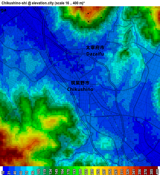
Below is the Elevation map of Chikushino-shi, which displays elevation range with different colors. Scale of the first map is from 16 to 400 m (52 to 1312 ft) with average elevation of 91.2 meters (=299 ft) [note 1]
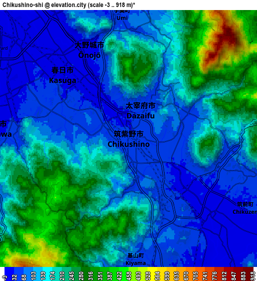
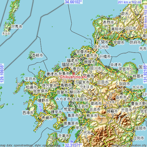
These maps also provides idea of topography and contour of this city, they are displayed at different zoom levels. More info about maps, scale and edge coordinates you can find below images.
| \ | Map #1 | Map #2 | Topo.Map |
| Scale [m] | 16..400 m | -3..918 m | × |
| Scale [ft] | 52..1312 ft | -10..3012 ft | × |
| Average | 91.2 m = 299 ft | 157.1 m = 515 ft | × |
| Width | 8.15 km = 5.1 mi | 16.3 km = 10.1 mi | 260.8 km = 162.1 mi |
| Height | 8.15 km = 5.1 mi | 16.3 km = 10.1 mi | 260.8 km = 162.1 mi |
| ↑Max Latitude | 33.532949° | 33.569573° | 34.66102° |
| Latitude at center | 33.49631° | 33.49631° | 33.49631° |
| ↓Min Latitude | 33.459655° | 33.422985° | 32.31571° |
| ← Min Longitude | 130.471655° | 130.427709° | 129.10935° |
| Longitude center | 130.5156° | 130.5156° | 130.5156° |
| →Max Longitude | 130.559545° | 130.603491° | 131.92185° |
Nearby cities:
Cities around Chikushino-shi sort by population:
• Fukuoka elevation 3 m
14.7 km,  321°
321°
• Kurume 10 m
20 km,  179°
179°
• Ōnojō 25 m
5.6 km, 321°
• Dazaifu 42 m
2 km,  22°
22°
• Tosu 17 m
14.4 km, 179°
• Amagi 38 m
15.5 km,  124°
124°
• Umi 41 m
8 km,  356°
356°
• Sasaguri 110 m
13.7 km,  13°
13°
• Kama 78 m
21.4 km,  78°
78°
• Asakura 51 m
20.9 km, 115°
• Ogōri 16 m
12.5 km,  165°
165°
• Kasuga 42 m
6 km,  303°
303°
Multilingual:
 En español:
Chikushino-shi elevación 37 m.
 En France:
Chikushino-shi élévation 37 m.
 Auf Deutsch:
Chikushino-shi höhe über dem Meeresspiegel ist 37 m.

Sources and notes:
- [note 1] Map square and city borders are not equal. Map elevation data is calculated only from area inside that square.
- [src 1] Elevation data from geonames database provided with same terms of usage.
- [src 2] The elevation map of Chikushino-shi is generated using elevation data from NASA's 3 arcsec (90m) resolution SRTM data.
- [src 3] Base (background) map © OpenStreetMap contributors tiles are generated by Geofabrik and OpenTopoMap.
Copyright & License:
This Chikushino-shi Elevation Map is licensed under CC BY-SA. You may reuse any part from this page, if you give a proper credit by linking to this URL:
 More info on terms of use page.