Tosu elevation
Tosu (Saga, Tosu Shi), Japan elevation is 17 meters and Tosu elevation in feet is 56 ft above sea level [src 1]. Tosu is a seat of a second-order administrative division (feature code) with elevation that is 68 meters (223 ft) smaller than average city elevation in Japan.
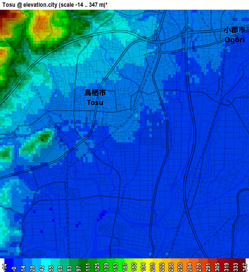
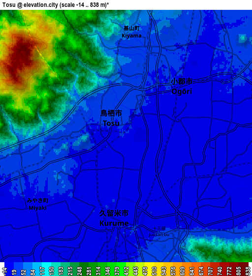
Below is the Elevation map of Tosu, which displays elevation range with different colors. Scale of the first map is from -14 to 347 m (-46 to 1138 ft) with average elevation of 26.1 meters (=86 ft) [note 1]
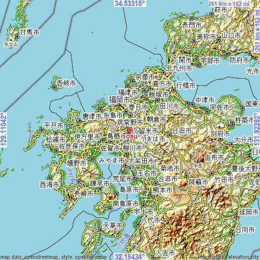
These maps also provides idea of topography and contour of this city, they are displayed at different zoom levels. More info about maps, scale and edge coordinates you can find below images.
| \ | Map #1 | Map #2 | Topo.Map |
| Scale [m] | -14..347 m | -14..838 m | × |
| Scale [ft] | -46..1138 ft | -46..2749 ft | × |
| Average | 26.1 m = 86 ft | 87.3 m = 286 ft | × |
| Width | 8.16 km = 5.1 mi | 16.32 km = 10.1 mi | 261.2 km = 162.3 mi |
| Height | 8.16 km = 5.1 mi | 16.32 km = 10.1 mi | 261.2 km = 162.3 mi |
| ↑Max Latitude | 33.403364° | 33.440042° | 34.53315° |
| Latitude at center | 33.36667° | 33.36667° | 33.36667° |
| ↓Min Latitude | 33.329961° | 33.293236° | 32.18434° |
| ← Min Longitude | 130.472725° | 130.428779° | 129.11042° |
| Longitude center | 130.51667° | 130.51667° | 130.51667° |
| →Max Longitude | 130.560615° | 130.604561° | 131.92292° |
Nearby cities:
Cities around Tosu sort by population:
• Kurume elevation 10 m
5.6 km,  180°
180°
• Chikushino-shi 37 m
14.4 km,  359°
359°
• Ōnojō 25 m
19.1 km,  349°
349°
• Dazaifu 42 m
16.3 km,  2°
2°
• Amagi 38 m
14 km,  65°
65°
• Tanushimarumachi-toyoki 16 m
15.6 km,  96°
96°
• Kanzakimachi-kanzaki 5 m
14.7 km,  244°
244°
• Asakura 51 m
19.5 km, 74°
• Kasuga 42 m
18.4 km,  343°
343°
• Chikugo 11 m
18.1 km,  187°
187°
• Kanzaki 19 m
17 km,  253°
253°
• Ogōri 16 m
3.8 km,  52°
52°
Multilingual:
 En español:
Tosu elevación 17 m.
 En France:
Tosu élévation 17 m.


Sources and notes:
- [note 1] Map square and city borders are not equal. Map elevation data is calculated only from area inside that square.
- [src 1] Elevation data from geonames database provided with same terms of usage.
- [src 2] The elevation map of Tosu is generated using elevation data from NASA's 3 arcsec (90m) resolution SRTM data.
- [src 3] Base (background) map © OpenStreetMap contributors tiles are generated by Geofabrik and OpenTopoMap.
Copyright & License:
This Tosu Elevation Map is licensed under CC BY-SA. You may reuse any part from this page, if you give a proper credit by linking to this URL:
 More info on terms of use page.