Sasayama elevation
Sasayama (Hyōgo, Sasayama-shi), Japan elevation is 202 meters and Sasayama elevation in feet is 663 ft above sea level [src 1]. Sasayama is a seat of a second-order administrative division (feature code) with elevation that is 117 meters (384 ft) bigger than average city elevation in Japan.
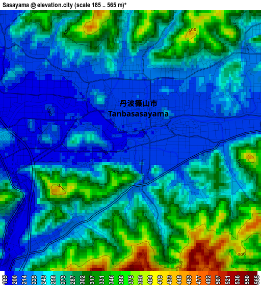
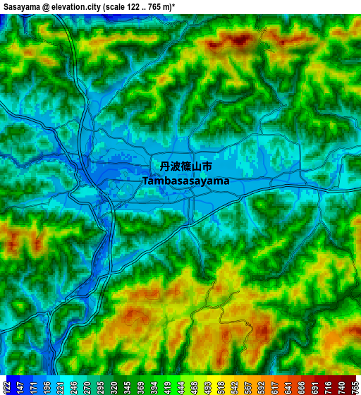
Below is the Elevation map of Sasayama, which displays elevation range with different colors. Scale of the first map is from 185 to 565 m (607 to 1854 ft) with average elevation of 266.7 meters (=875 ft) [note 1]
These maps also provides idea of topography and contour of this city, they are displayed at different zoom levels. More info about maps, scale and edge coordinates you can find below images.
| \ | Map #1 | Map #2 | Topo.Map |
| Scale [m] | 185..565 m | 122..765 m | × |
| Scale [ft] | 607..1854 ft | 400..2510 ft | × |
| Average | 266.7 m = 875 ft | 346.1 m = 1135 ft | × |
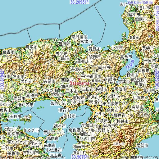
| Width | 8 km = 5 mi | 16 km = 9.9 mi | 255.9 km = 159 mi |
| Height | 8 km = 5 mi | 16 km = 9.9 mi | 255.9 km = 159 mi |
| ↑Max Latitude | 35.102631° | 35.138575° | 36.20951° |
| Latitude at center | 35.06667° | 35.06667° | 35.06667° |
| ↓Min Latitude | 35.030694° | 34.994701° | 33.9076° |
| ← Min Longitude | 135.172725° | 135.128779° | 133.81042° |
| Longitude center | 135.21667° | 135.21667° | 135.21667° |
| →Max Longitude | 135.260615° | 135.304561° | 136.62292° |
Nearby cities:
Cities around Sasayama sort by population:
• Takarazuka elevation 29 m
32.4 km,  156°
156°
• Kawanishi 21 m
33.2 km,  146°
146°
• Sandachō 147 m
20.3 km,  177°
177°
• Fukuchiyama 20 m
27.5 km,  340°
340°
• Ayabe 46 m
26.1 km,  6°
6°
• Nishiwaki 57 m
23.9 km,  247°
247°
• Yashiro 67 m
28.2 km,  233°
233°
• Kawanishi 105 m
26.5 km,  141°
141°
• Nantan 248 m
25.5 km,  79°
79°
• Katō 125 m
23.5 km, 227°
• Tanba 91 m
19.2 km,  302°
302°
• Sanda 204 m
13.3 km, 181°
Multilingual:
 En español:
Sasayama elevación 202 m.
 En France:
Sasayama élévation 202 m.
 Auf Deutsch:
Sasayama höhe über dem Meeresspiegel ist 202 m.

Sources and notes:
- [note 1] Map square and city borders are not equal. Map elevation data is calculated only from area inside that square.
- [src 1] Elevation data from geonames database provided with same terms of usage.
- [src 2] The elevation map of Sasayama is generated using elevation data from NASA's 3 arcsec (90m) resolution SRTM data.
- [src 3] Base (background) map © OpenStreetMap contributors tiles are generated by Geofabrik and OpenTopoMap.
Copyright & License:
This Sasayama Elevation Map is licensed under CC BY-SA. You may reuse any part from this page, if you give a proper credit by linking to this URL:
 More info on terms of use page.