Kawanishi elevation
Kawanishi (Hyōgo), Japan elevation is 21 meters and Kawanishi elevation in feet is 69 ft above sea level [src 1]. Kawanishi is a populated place (feature code) with elevation that is 64 meters (210 ft) smaller than average city elevation in Japan.
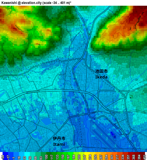
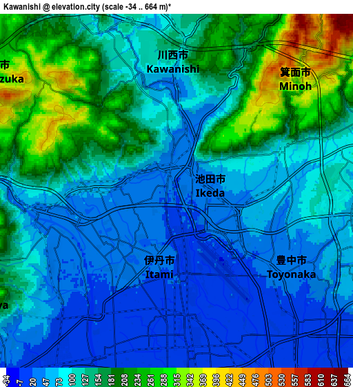
Below is the Elevation map of Kawanishi, which displays elevation range with different colors. Scale of the first map is from -34 to 401 m (-112 to 1316 ft) with average elevation of 74.1 meters (=243 ft) [note 1]
These maps also provides idea of topography and contour of this city, they are displayed at different zoom levels. More info about maps, scale and edge coordinates you can find below images.
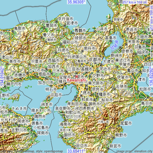
| \ | Map #1 | Map #2 | Topo.Map |
| Scale [m] | -34..401 m | -34..664 m | × |
| Scale [ft] | -112..1316 ft | -112..2178 ft | × |
| Average | 74.1 m = 243 ft | 118.4 m = 388 ft | × |
| Width | 8.02 km = 5 mi | 16.05 km = 10 mi | 256.7 km = 159.5 mi |
| Height | 8.02 km = 5 mi | 16.05 km = 10 mi | 256.7 km = 159.5 mi |
| ↑Max Latitude | 34.85274° | 34.888795° | 35.96305° |
| Latitude at center | 34.81667° | 34.81667° | 34.81667° |
| ↓Min Latitude | 34.780584° | 34.744482° | 33.65411° |
| ← Min Longitude | 135.372725° | 135.328779° | 134.01042° |
| Longitude center | 135.41667° | 135.41667° | 135.41667° |
| →Max Longitude | 135.460615° | 135.504561° | 136.82292° |
Nearby cities:
Cities around Kawanishi sort by population:
• Osaka elevation 24 m
15.7 km,  150°
150°
• Nishinomiya-hama 5 m
13.6 km,  214°
214°
• Amagasaki 1 m
11.1 km,  180°
180°
• Toyonaka 31 m
6.1 km,  128°
128°
• Suita 4 m
10.9 km,  124°
124°
• Ibaraki 18 m
13.8 km,  90°
90°
• Takarazuka 29 m
5.8 km,  250°
250°
• Itami 22 m
3.9 km,  201°
201°
• Mino 76 m
5 km,  76°
76°
• Ikeda 26 m
1.3 km,  63°
63°
• Ashiya 14 m
14.3 km,  226°
226°
• Kawanishi 105 m
7.4 km,  347°
347°
Multilingual:
 En español:
Kawanishi elevación 21 m.
 En France:
Kawanishi élévation 21 m.
 Auf Deutsch:
Kawanishi höhe über dem Meeresspiegel ist 21 m.

Sources and notes:
- [note 1] Map square and city borders are not equal. Map elevation data is calculated only from area inside that square.
- [src 1] Elevation data from geonames database provided with same terms of usage.
- [src 2] The elevation map of Kawanishi is generated using elevation data from NASA's 3 arcsec (90m) resolution SRTM data.
- [src 3] Base (background) map © OpenStreetMap contributors tiles are generated by Geofabrik and OpenTopoMap.
Copyright & License:
This Kawanishi Elevation Map is licensed under CC BY-SA. You may reuse any part from this page, if you give a proper credit by linking to this URL:
 More info on terms of use page.