Shibukawa elevation
Shibukawa (Gunma, Shibukawa-shi), Japan elevation is 202 meters and Shibukawa elevation in feet is 663 ft above sea level [src 1]. Shibukawa is a seat of a second-order administrative division (feature code) with elevation that is 117 meters (384 ft) bigger than average city elevation in Japan.
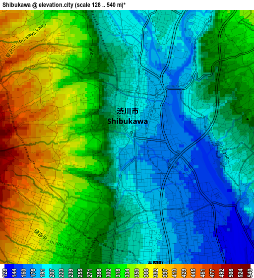
Below is the Elevation map of Shibukawa, which displays elevation range with different colors. Scale of the first map is from 128 to 540 m (420 to 1772 ft) with average elevation of 272.7 meters (=895 ft) [note 1]
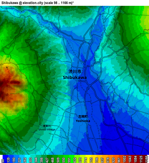
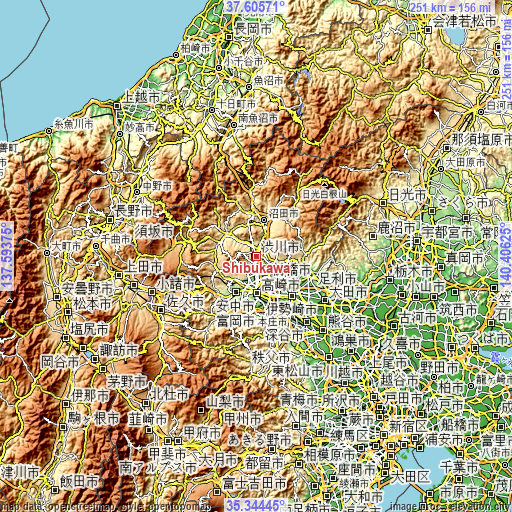
These maps also provides idea of topography and contour of this city, they are displayed at different zoom levels. More info about maps, scale and edge coordinates you can find below images.
| \ | Map #1 | Map #2 | Topo.Map |
| Scale [m] | 128..540 m | 98..1166 m | × |
| Scale [ft] | 420..1772 ft | 322..3825 ft | × |
| Average | 272.7 m = 895 ft | 351.7 m = 1154 ft | × |
| Width | 7.86 km = 4.9 mi | 15.71 km = 9.8 mi | 251.4 km = 156.2 mi |
| Height | 7.86 km = 4.9 mi | 15.71 km = 9.8 mi | 251.4 km = 156.2 mi |
| ↑Max Latitude | 36.518655° | 36.553964° | 37.60571° |
| Latitude at center | 36.48333° | 36.48333° | 36.48333° |
| ↓Min Latitude | 36.447989° | 36.412631° | 35.34445° |
| ← Min Longitude | 138.956055° | 138.912109° | 137.59375° |
| Longitude center | 139° | 139° | 139° |
| →Max Longitude | 139.043945° | 139.087891° | 140.40625° |
Nearby cities:
Cities around Shibukawa sort by population:
• Maebashi elevation 107 m
11.9 km,  141°
141°
• Takasaki 93 m
16.7 km,  174°
174°
• Isesaki 62 m
25.8 km, 135°
• Fujioka 94 m
27.1 km, 166°
• Annaka 170 m
19.4 km,  208°
208°
• Numata 376 m
17.3 km,  14°
14°
• Tamamura 68 m
22.9 km,  152°
152°
• Kanekomachi 193 m
8.1 km,  182°
182°
• Yoshii 125 m
26 km, 183°
• Ōmamachō-ōmama 182 m
25.3 km,  103°
103°
• Nakanojōmachi 371 m
18.3 km,  309°
309°
• Midori 254 m
25.8 km, 99°
Multilingual:
 En español:
Shibukawa elevación 202 m.
 En France:
Shibukawa élévation 202 m.
 Auf Deutsch:
Shibukawa höhe über dem Meeresspiegel ist 202 m.

Sources and notes:
- [note 1] Map square and city borders are not equal. Map elevation data is calculated only from area inside that square.
- [src 1] Elevation data from geonames database provided with same terms of usage.
- [src 2] The elevation map of Shibukawa is generated using elevation data from NASA's 3 arcsec (90m) resolution SRTM data.
- [src 3] Base (background) map © OpenStreetMap contributors tiles are generated by Geofabrik and OpenTopoMap.
Copyright & License:
This Shibukawa Elevation Map is licensed under CC BY-SA. You may reuse any part from this page, if you give a proper credit by linking to this URL:
 More info on terms of use page.