Ueno-ebisumachi elevation
Ueno-ebisumachi (Mie, Iga-shi), Japan elevation is 149 meters and Ueno-ebisumachi elevation in feet is 489 ft above sea level [src 1]. Ueno-ebisumachi is a populated place (feature code) with elevation that is 64 meters (210 ft) bigger than average city elevation in Japan.
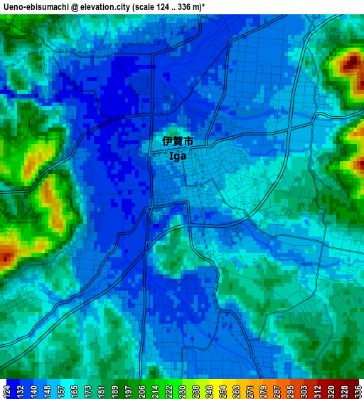
Below is the Elevation map of Ueno-ebisumachi, which displays elevation range with different colors. Scale of the first map is from 124 to 336 m (407 to 1102 ft) with average elevation of 162.3 meters (=532 ft) [note 1]
These maps also provides idea of topography and contour of this city, they are displayed at different zoom levels. More info about maps, scale and edge coordinates you can find below images.
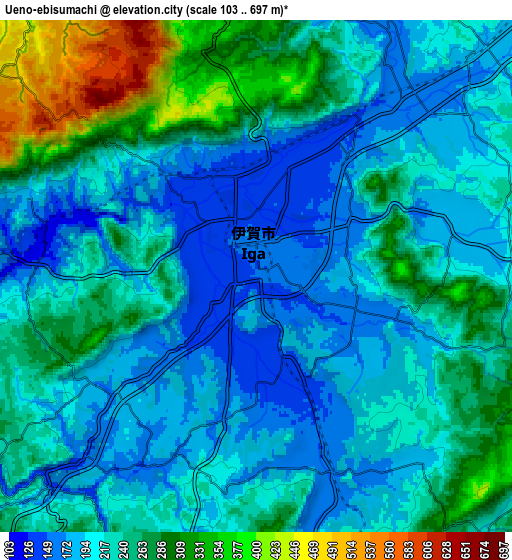
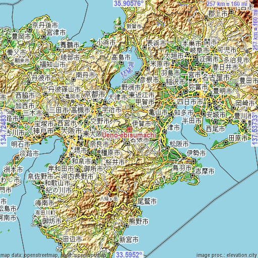
| \ | Map #1 | Map #2 | Topo.Map |
| Scale [m] | 124..336 m | 103..697 m | × |
| Scale [ft] | 407..1102 ft | 338..2287 ft | × |
| Average | 162.3 m = 532 ft | 229.2 m = 752 ft | × |
| Width | 8.03 km = 5 mi | 16.06 km = 10 mi | 256.9 km = 159.6 mi |
| Height | 8.03 km = 5 mi | 16.06 km = 10 mi | 256.9 km = 159.6 mi |
| ↑Max Latitude | 34.794656° | 34.830736° | 35.90576° |
| Latitude at center | 34.75856° | 34.75856° | 34.75856° |
| ↓Min Latitude | 34.722448° | 34.686321° | 33.5952° |
| ← Min Longitude | 136.087135° | 136.043189° | 134.72483° |
| Longitude center | 136.13108° | 136.13108° | 136.13108° |
| →Max Longitude | 136.175025° | 136.218971° | 137.53733° |
Nearby cities:
Cities around Ueno-ebisumachi sort by population:
• Nara-shi elevation 68 m
30.9 km,  254°
254°
• Nabari 192 m
16.4 km,  195°
195°
• Kameyama 54 m
30.8 km,  70°
70°
• Minakuchichō-matoba 171 m
23.4 km,  7°
7°
• Hino 182 m
29 km,  22°
22°
• Haibara-akanedai 345 m
30 km,  213°
213°
• Rittō 107 m
32.2 km,  338°
338°
• Jōyō 88 m
31.2 km,  287°
287°
• Konan 137 m
26.9 km,  353°
353°
• Kizugawa 56 m
26.7 km,  264°
264°
• Kōka 170 m
24.8 km, 5°
• Iga 152 m
0.3 km,  101°
101°
Multilingual:
 En español:
Ueno-ebisumachi elevación 149 m.
 En France:
Ueno-ebisumachi élévation 149 m.
 Auf Deutsch:
Ueno-ebisumachi höhe über dem Meeresspiegel ist 149 m.

Sources and notes:
- [note 1] Map square and city borders are not equal. Map elevation data is calculated only from area inside that square.
- [src 1] Elevation data from geonames database provided with same terms of usage.
- [src 2] The elevation map of Ueno-ebisumachi is generated using elevation data from NASA's 3 arcsec (90m) resolution SRTM data.
- [src 3] Base (background) map © OpenStreetMap contributors tiles are generated by Geofabrik and OpenTopoMap.
Copyright & License:
This Ueno-ebisumachi Elevation Map is licensed under CC BY-SA. You may reuse any part from this page, if you give a proper credit by linking to this URL:
 More info on terms of use page.