Amman elevation
Amman, Jordan elevation is 757 meters and Amman elevation in feet is 2484 ft above sea level [src 1]. Amman is a capital of a political entity (feature code) with elevation that is 65 meters (213 ft) bigger than average city elevation in Jordan.
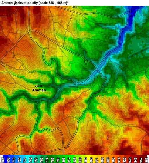
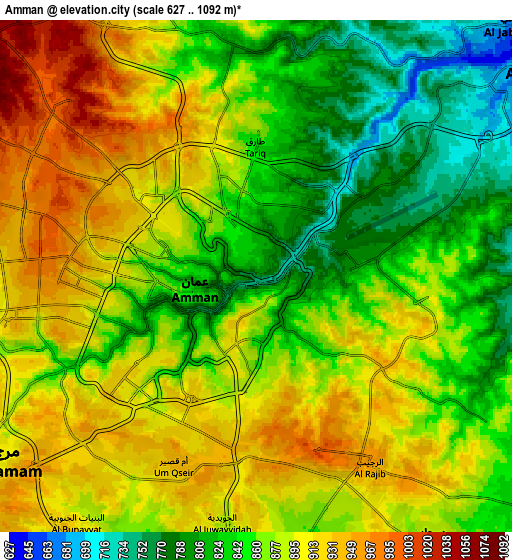
Below is the Elevation map of Amman, which displays elevation range with different colors. Scale of the first map is from 688 to 968 m (2257 to 3176 ft) with average elevation of 847.8 meters (=2781 ft) [note 1]
These maps also provides idea of topography and contour of this city, they are displayed at different zoom levels. More info about maps, scale and edge coordinates you can find below images.
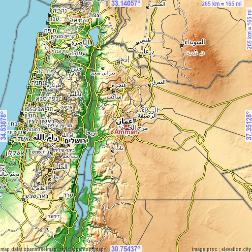
| \ | Map #1 | Map #2 | Topo.Map |
| Scale [m] | 688..968 m | 627..1092 m | × |
| Scale [ft] | 2257..3176 ft | 2057..3583 ft | × |
| Average | 847.8 m = 2781 ft | 871.7 m = 2860 ft | × |
| Width | 8.29 km = 5.2 mi | 16.58 km = 10.3 mi | 265.3 km = 164.8 mi |
| Height | 8.29 km = 5.2 mi | 16.58 km = 10.3 mi | 265.3 km = 164.8 mi |
| ↑Max Latitude | 31.992498° | 32.029762° | 33.14057° |
| Latitude at center | 31.95522° | 31.95522° | 31.95522° |
| ↓Min Latitude | 31.917927° | 31.880618° | 30.75437° |
| ← Min Longitude | 35.901085° | 35.857139° | 34.53878° |
| Longitude center | 35.94503° | 35.94503° | 35.94503° |
| →Max Longitude | 35.988975° | 36.032921° | 37.35128° |
Nearby cities:
Cities around Amman sort by population:
• Russeifa elevation 614 m
11.8 km,  53°
53°
• Wādī as Sīr 764 m
12 km,  269°
269°
• Al Jubayhah 989 m
7.6 km,  324°
324°
• Saḩāb 872 m
11 km,  149°
149°
• Ḩayy al Quwaysimah 983 m
5 km,  174°
174°
• Umm as Summāq 934 m
11.6 km,  227°
227°
• Jāwā 889 m
11.4 km,  182°
182°
• Ḩayy al Bunayyāt 925 m
8.7 km,  220°
220°
• Rujm ash Shāmī al Gharbī 804 m
14.3 km,  156°
156°
• Ar Ruşayfah 671 m
10.8 km, 50°
• Al Juwayyidah 905 m
7.7 km,  189°
189°
• Al ‘Abdallī 891 m
3.6 km,  287°
287°
Multilingual:
 En español:
Ammán elevación 757 m.
 En France:
Amman élévation 757 m.


Sources and notes:
- [note 1] Map square and city borders are not equal. Map elevation data is calculated only from area inside that square.
- [src 1] Elevation data from geonames database provided with same terms of usage.
- [src 2] The elevation map of Amman is generated using elevation data from NASA's 3 arcsec (90m) resolution SRTM data.
- [src 3] Base (background) map © OpenStreetMap contributors tiles are generated by Geofabrik and OpenTopoMap.
Copyright & License:
This Amman Elevation Map is licensed under CC BY-SA. You may reuse any part from this page, if you give a proper credit by linking to this URL:
 More info on terms of use page.