Wādī as Sīr elevation
Wādī as Sīr (Amman), Jordan elevation is 764 meters and Wādī as Sīr elevation in feet is 2507 ft above sea level [src 1]. Wādī as Sīr is a seat of a second-order administrative division (feature code) with elevation that is 72 meters (236 ft) bigger than average city elevation in Jordan.
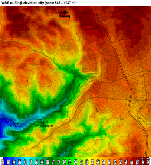
Below is the Elevation map of Wādī as Sīr, which displays elevation range with different colors. Scale of the first map is from 548 to 1037 m (1798 to 3402 ft) with average elevation of 879.6 meters (=2886 ft) [note 1]
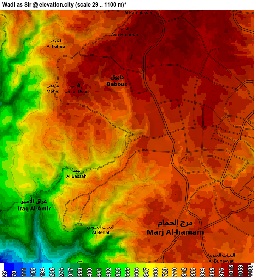
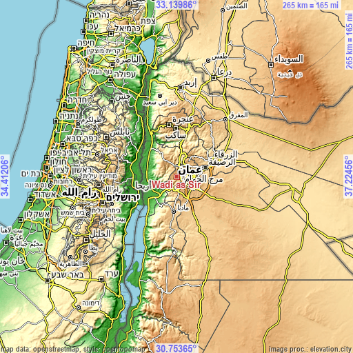
These maps also provides idea of topography and contour of this city, they are displayed at different zoom levels. More info about maps, scale and edge coordinates you can find below images.
| \ | Map #1 | Map #2 | Topo.Map |
| Scale [m] | 548..1037 m | 29..1100 m | × |
| Scale [ft] | 1798..3402 ft | 95..3609 ft | × |
| Average | 879.6 m = 2886 ft | 822.4 m = 2698 ft | × |
| Width | 8.29 km = 5.2 mi | 16.58 km = 10.3 mi | 265.3 km = 164.8 mi |
| Height | 8.29 km = 5.2 mi | 16.58 km = 10.3 mi | 265.3 km = 164.8 mi |
| ↑Max Latitude | 31.991779° | 32.029042° | 33.13986° |
| Latitude at center | 31.9545° | 31.9545° | 31.9545° |
| ↓Min Latitude | 31.917206° | 31.879897° | 30.75365° |
| ← Min Longitude | 35.774365° | 35.730419° | 34.41206° |
| Longitude center | 35.81831° | 35.81831° | 35.81831° |
| →Max Longitude | 35.862255° | 35.906201° | 37.22456° |
Nearby cities:
Cities around Wādī as Sīr sort by population:
• Amman elevation 757 m
12 km,  89°
89°
• As Salţ 816 m
12.7 km,  317°
317°
• Al Jubayhah 989 m
9.8 km,  50°
50°
• Ḩayy al Quwaysimah 983 m
13.3 km,  111°
111°
• Umm as Summāq 934 m
8.4 km,  156°
156°
• Ḩayy al Bunayyāt 925 m
9 km,  136°
136°
• Yarqā 594 m
11.7 km,  281°
281°
• Al Juwayyidah 905 m
13 km,  125°
125°
• ‘Ayn al Bāshā 663 m
11.5 km,  6°
6°
• Nā‘ūr 797 m
8.9 km,  176°
176°
• Al ‘Abdallī 891 m
8.6 km,  82°
82°
• Al Fuḩayş 918 m
6.6 km,  327°
327°
Multilingual:
 En español:
Wādī as Sīr elevación 764 m.
 En France:
Wādī as Sīr élévation 764 m.
 Auf Deutsch:
Wādī as Sīr höhe über dem Meeresspiegel ist 764 m.

Sources and notes:
- [note 1] Map square and city borders are not equal. Map elevation data is calculated only from area inside that square.
- [src 1] Elevation data from geonames database provided with same terms of usage.
- [src 2] The elevation map of Wādī as Sīr is generated using elevation data from NASA's 3 arcsec (90m) resolution SRTM data.
- [src 3] Base (background) map © OpenStreetMap contributors tiles are generated by Geofabrik and OpenTopoMap.
Copyright & License:
This Wādī as Sīr Elevation Map is licensed under CC BY-SA. You may reuse any part from this page, if you give a proper credit by linking to this URL:
 More info on terms of use page.