Jāwā elevation
Jāwā (Amman), Jordan elevation is 889 meters and Jāwā elevation in feet is 2917 ft above sea level [src 1]. Jāwā is a populated place (feature code) with elevation that is 197 meters (646 ft) bigger than average city elevation in Jordan.
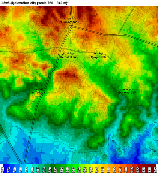
Below is the Elevation map of Jāwā, which displays elevation range with different colors. Scale of the first map is from 766 to 942 m (2513 to 3091 ft) with average elevation of 846.7 meters (=2778 ft) [note 1]
These maps also provides idea of topography and contour of this city, they are displayed at different zoom levels. More info about maps, scale and edge coordinates you can find below images.
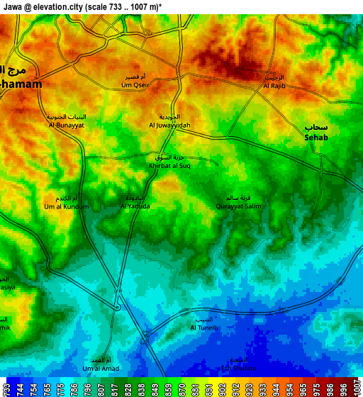
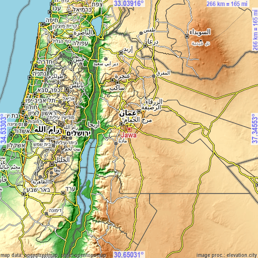
| \ | Map #1 | Map #2 | Topo.Map |
| Scale [m] | 766..942 m | 733..1007 m | × |
| Scale [ft] | 2513..3091 ft | 2405..3304 ft | × |
| Average | 846.7 m = 2778 ft | 847.7 m = 2781 ft | × |
| Width | 8.3 km = 5.2 mi | 16.6 km = 10.3 mi | 265.6 km = 165 mi |
| Height | 8.3 km = 5.2 mi | 16.6 km = 10.3 mi | 265.6 km = 165 mi |
| ↑Max Latitude | 31.88979° | 31.927095° | 33.03916° |
| Latitude at center | 31.85247° | 31.85247° | 31.85247° |
| ↓Min Latitude | 31.815135° | 31.777785° | 30.65031° |
| ← Min Longitude | 35.895335° | 35.851389° | 34.53303° |
| Longitude center | 35.93928° | 35.93928° | 35.93928° |
| →Max Longitude | 35.983225° | 36.027171° | 37.34553° |
Nearby cities:
Cities around Jāwā sort by population:
• Amman elevation 757 m
11.4 km,  2°
2°
• Wādī as Sīr 764 m
16.1 km,  314°
314°
• Saḩāb 872 m
6.5 km,  72°
72°
• Ḩayy al Quwaysimah 983 m
6.5 km,  8°
8°
• Umm as Summāq 934 m
8.8 km,  294°
294°
• Ḩayy al Bunayyāt 925 m
7.1 km, 313°
• Ḩisbān 851 m
13.6 km,  243°
243°
• Al ‘Abdallī 891 m
12.9 km,  346°
346°
• Nā‘ūr 797 m
11.1 km,  282°
282°
• Umm al Basātīn 846 m
6.6 km, 241°
• Rujm ash Shāmī al Gharbī 804 m
6.4 km,  105°
105°
• Al Juwayyidah 905 m
3.9 km, 349°
Multilingual:
 En español:
Jāwā elevación 889 m.
 En France:
Jāwā élévation 889 m.


Sources and notes:
- [note 1] Map square and city borders are not equal. Map elevation data is calculated only from area inside that square.
- [src 1] Elevation data from geonames database provided with same terms of usage.
- [src 2] The elevation map of Jāwā is generated using elevation data from NASA's 3 arcsec (90m) resolution SRTM data.
- [src 3] Base (background) map © OpenStreetMap contributors tiles are generated by Geofabrik and OpenTopoMap.
Copyright & License:
This Jāwā Elevation Map is licensed under CC BY-SA. You may reuse any part from this page, if you give a proper credit by linking to this URL:
 More info on terms of use page.