Al Azraq ash Shamālī elevation
Al Azraq ash Shamālī (Zarqa), Jordan elevation is 521 meters and Al Azraq ash Shamālī elevation in feet is 1709 ft above sea level [src 1]. Al Azraq ash Shamālī is a populated place (feature code) with elevation that is 171 meters (561 ft) smaller than average city elevation in Jordan.
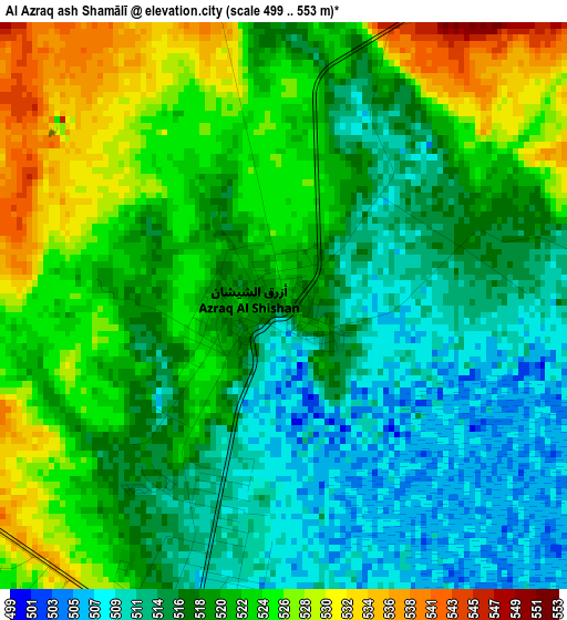
Below is the Elevation map of Al Azraq ash Shamālī, which displays elevation range with different colors. Scale of the first map is from 499 to 553 m (1637 to 1814 ft) with average elevation of 519.3 meters (=1704 ft) [note 1]
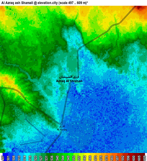
These maps also provides idea of topography and contour of this city, they are displayed at different zoom levels. More info about maps, scale and edge coordinates you can find below images.
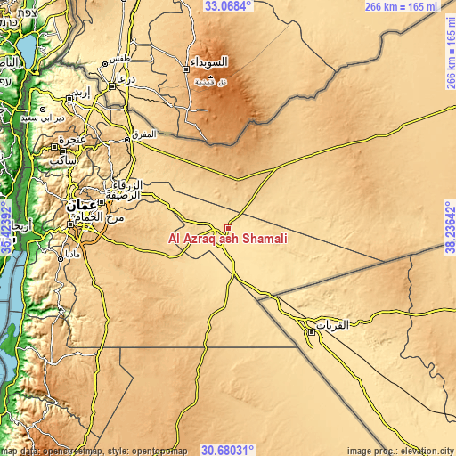
| \ | Map #1 | Map #2 | Topo.Map |
| Scale [m] | 499..553 m | 497..609 m | × |
| Scale [ft] | 1637..1814 ft | 1631..1998 ft | × |
| Average | 519.3 m = 1704 ft | 528.4 m = 1734 ft | × |
| Width | 8.3 km = 5.2 mi | 16.6 km = 10.3 mi | 265.5 km = 165 mi |
| Height | 8.3 km = 5.2 mi | 16.6 km = 10.3 mi | 265.5 km = 165 mi |
| ↑Max Latitude | 31.919398° | 31.956691° | 33.0684° |
| Latitude at center | 31.88209° | 31.88209° | 31.88209° |
| ↓Min Latitude | 31.844767° | 31.807429° | 30.68031° |
| ← Min Longitude | 36.786225° | 36.742279° | 35.42392° |
| Longitude center | 36.83017° | 36.83017° | 36.83017° |
| →Max Longitude | 36.874115° | 36.918061° | 38.23642° |
Nearby cities:
Cities around Al Azraq ash Shamālī sort by population:
• Zarqa elevation 625 m
73.1 km,  286°
286°
• Russeifa 614 m
75.5 km,  281°
281°
• Şabḩā 834 m
58.3 km,  327°
327°
• Umm al Qiţţayn 962 m
51.7 km,  338°
338°
• Al Hāshimīyah 559 m
72.3 km, 292°
• Al Muwaqqar 890 m
68.5 km,  263°
263°
• Umm al Jimāl 674 m
66 km,  318°
318°
• Al Khālidīyah 605 m
59.6 km,  303°
303°
• Az̧ Z̧ulayl 572 m
58.3 km, 297°
• Muthallath Şabḩā 750 m
54.2 km, 320°
• Dayr al Kahf 1016 m
43.7 km,  1°
1°
• Muthallath al Azraq 516 m
5.7 km,  194°
194°
Multilingual:
 En español:
Al Azraq ash Shamālī elevación 521 m.
 En France:
Al Azraq ash Shamālī élévation 521 m.
 Auf Deutsch:
Al Azraq ash Shamālī höhe über dem Meeresspiegel ist 521 m.

Sources and notes:
- [note 1] Map square and city borders are not equal. Map elevation data is calculated only from area inside that square.
- [src 1] Elevation data from geonames database provided with same terms of usage.
- [src 2] The elevation map of Al Azraq ash Shamālī is generated using elevation data from NASA's 3 arcsec (90m) resolution SRTM data.
- [src 3] Base (background) map © OpenStreetMap contributors tiles are generated by Geofabrik and OpenTopoMap.
Copyright & License:
This Al Azraq ash Shamālī Elevation Map is licensed under CC BY-SA. You may reuse any part from this page, if you give a proper credit by linking to this URL:
 More info on terms of use page.