Umm al Jimāl elevation
Umm al Jimāl (Mafraq), Jordan elevation is 674 meters and Umm al Jimāl elevation in feet is 2211 ft above sea level [src 1]. Umm al Jimāl is a seat of a third-order administrative division (feature code) with elevation that is 18 meters (59 ft) smaller than average city elevation in Jordan.
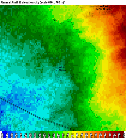
Below is the Elevation map of Umm al Jimāl, which displays elevation range with different colors. Scale of the first map is from 640 to 763 m (2100 to 2503 ft) with average elevation of 689.4 meters (=2262 ft) [note 1]
These maps also provides idea of topography and contour of this city, they are displayed at different zoom levels. More info about maps, scale and edge coordinates you can find below images.
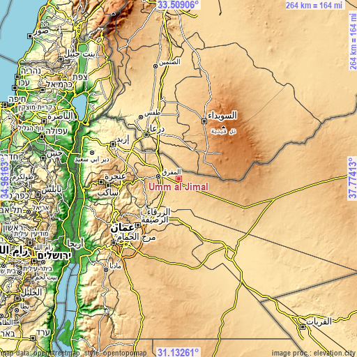
| \ | Map #1 | Topo.Map |
| Scale [m] | 640..763 m | × |
| Scale [ft] | 2100..2503 ft | × |
| Average | 689.4 m = 2262 ft | × |
| Width | 8.26 km = 5.1 mi | 264.2 km = 164.2 mi |
| Height | 8.26 km = 5.1 mi | 264.2 km = 164.2 mi |
| ↑Max Latitude | 32.365756° | 33.50906° |
| Latitude at center | 32.32863° | 32.32863° |
| ↓Min Latitude | 32.291489° | 31.13261° |
| ← Min Longitude | 36.323935° | 34.96163° |
| Longitude center | 36.36788° | 36.36788° |
| →Max Longitude | 36.411825° | 37.77413° |
Nearby cities:
Cities around Umm al Jimāl sort by population:
• Mafraq elevation 705 m
15.1 km,  276°
276°
• Rehab 896 m
26 km,  268°
268°
• Al Ḩamrā’ 697 m
23.7 km,  301°
301°
• Şabḩā 834 m
12.6 km,  90°
90°
• Umm al Qiţţayn 962 m
24.5 km, 93°
• Bal‘amā 673 m
28.2 km,  248°
248°
• Manshīyat Banī Ḩasan 820 m
27.5 km, 279°
• Az̧ Z̧ulayl 572 m
24.5 km,  199°
199°
• Samā as Sirḩān 613 m
19.4 km,  323°
323°
• Al Khālidīyah 605 m
17.7 km, 200°
• Muthallath Jāmi‘at Āl al Bayt 679 m
12.8 km, 278°
• Muthallath Şabḩā 750 m
12.1 km,  129°
129°
Multilingual:
 En español:
Umm al Jimāl elevación 674 m.
 En France:
Umm al Jimāl élévation 674 m.
 Auf Deutsch:
Umm al Jimāl höhe über dem Meeresspiegel ist 674 m.

Sources and notes:
- [note 1] Map square and city borders are not equal. Map elevation data is calculated only from area inside that square.
- [src 1] Elevation data from geonames database provided with same terms of usage.
- [src 2] The elevation map of Umm al Jimāl is generated using elevation data from NASA's 3 arcsec (90m) resolution SRTM data.
- [src 3] Base (background) map © OpenStreetMap contributors tiles are generated by Geofabrik and OpenTopoMap.
Copyright & License:
This Umm al Jimāl Elevation Map is licensed under CC BY-SA. You may reuse any part from this page, if you give a proper credit by linking to this URL:
 More info on terms of use page.