Old Harbour elevation
Old Harbour (Saint Catherine), Jamaica elevation is 30 meters and Old Harbour elevation in feet is 98 ft above sea level [src 1]. Old Harbour is a populated place (feature code) with elevation that is 185 meters (607 ft) smaller than average city elevation in Jamaica.
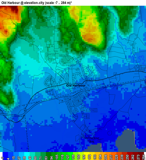
Below is the Elevation map of Old Harbour, which displays elevation range with different colors. Scale of the first map is from -7 to 284 m (-23 to 932 ft) with average elevation of 46.7 meters (=153 ft) [note 1]
These maps also provides idea of topography and contour of this city, they are displayed at different zoom levels. More info about maps, scale and edge coordinates you can find below images.
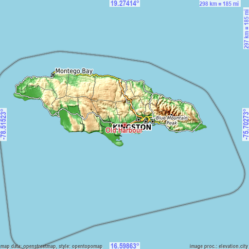
| \ | Map #1 | Map #2 | Topo.Map |
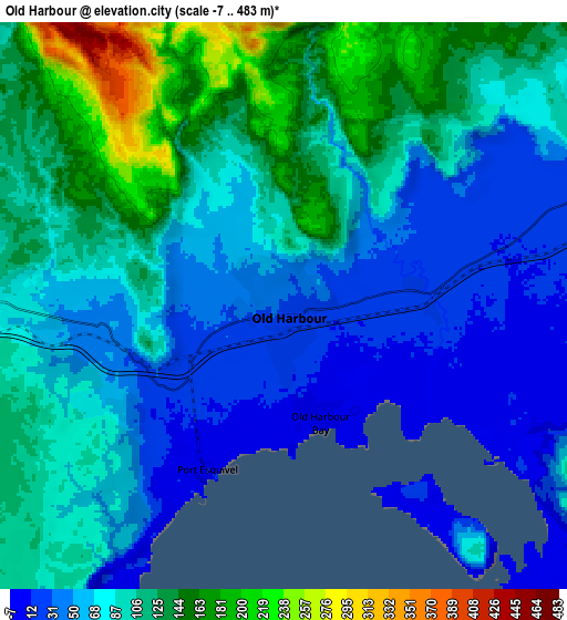
| Scale [m] | -7..284 m | -7..483 m | × |
| Scale [ft] | -23..932 ft | -23..1585 ft | × |
| Average | 46.7 m = 153 ft | 87 m = 285 ft | × |
| Width | 9.3 km = 5.8 mi | 18.59 km = 11.6 mi | 297.5 km = 184.9 mi |
| Height | 9.3 km = 5.8 mi | 18.59 km = 11.6 mi | 297.5 km = 184.9 mi |
| ↑Max Latitude | 17.983243° | 18.025037° | 19.27414° |
| Latitude at center | 17.94144° | 17.94144° | 17.94144° |
| ↓Min Latitude | 17.899627° | 17.857804° | 16.59863° |
| ← Min Longitude | -77.152925° | -77.196871° | -78.51523° |
| Longitude center | -77.10898° | -77.10898° | -77.10898° |
| →Max Longitude | -77.065035° | -77.021089° | -75.70273° |
Nearby cities:
Cities around Old Harbour sort by population:
• Spanish Town elevation 31 m
17 km,  71°
71°
• Portmore 139 m
24 km,  87°
87°
• May Pen 81 m
14.6 km,  280°
280°
• Linstead 119 m
23.2 km,  20°
20°
• Bog Walk 86 m
20.9 km,  31°
31°
• Hayes 38 m
15.4 km,  241°
241°
• Old Harbour Bay 5 m
3.8 km,  160°
160°
• Lionel Town 11 m
20.2 km,  223°
223°
• Point Hill 613 m
16.5 km,  0°
0°
• Chapelton 271 m
23 km,  313°
313°
• Lluidas Vale 387 m
20.9 km,  348°
348°
• Race Course 20 m
21.5 km, 238°
Multilingual:
 En español:
Old Harbour elevación 30 m.
 En France:
Old Harbour élévation 30 m.
 Auf Deutsch:
Old Harbour höhe über dem Meeresspiegel ist 30 m.

Sources and notes:
- [note 1] Map square and city borders are not equal. Map elevation data is calculated only from area inside that square.
- [src 1] Elevation data from geonames database provided with same terms of usage.
- [src 2] The elevation map of Old Harbour is generated using elevation data from NASA's 3 arcsec (90m) resolution SRTM data.
- [src 3] Base (background) map © OpenStreetMap contributors tiles are generated by Geofabrik and OpenTopoMap.
Copyright & License:
This Old Harbour Elevation Map is licensed under CC BY-SA. You may reuse any part from this page, if you give a proper credit by linking to this URL:
 More info on terms of use page.