Bog Walk elevation
Bog Walk (Saint Catherine, Bogwalk), Jamaica elevation is 86 meters and Bog Walk elevation in feet is 282 ft above sea level [src 1]. Bog Walk is a populated place (feature code) with elevation that is 129 meters (423 ft) smaller than average city elevation in Jamaica.
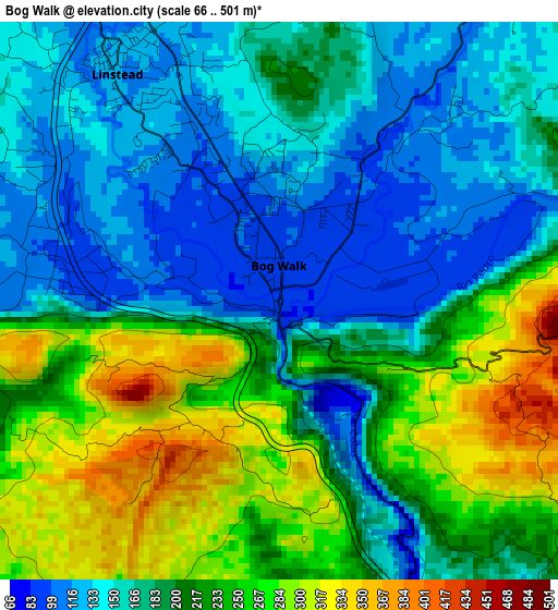
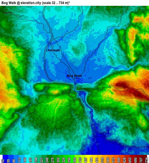
Below is the Elevation map of Bog Walk, which displays elevation range with different colors. Scale of the first map is from 66 to 501 m (217 to 1644 ft) with average elevation of 199.5 meters (=655 ft) [note 1]
These maps also provides idea of topography and contour of this city, they are displayed at different zoom levels. More info about maps, scale and edge coordinates you can find below images.
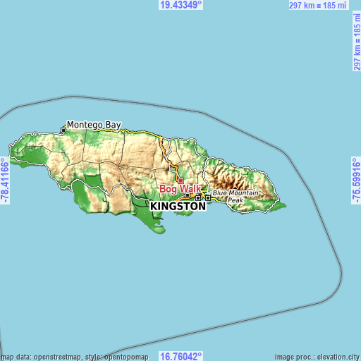
| \ | Map #1 | Map #2 | Topo.Map |
| Scale [m] | 66..501 m | 32..734 m | × |
| Scale [ft] | 217..1644 ft | 105..2408 ft | × |
| Average | 199.5 m = 655 ft | 231.9 m = 761 ft | × |
| Width | 9.29 km = 5.8 mi | 18.58 km = 11.5 mi | 297.2 km = 184.7 mi |
| Height | 9.29 km = 5.8 mi | 18.58 km = 11.5 mi | 297.2 km = 184.7 mi |
| ↑Max Latitude | 18.143815° | 18.185571° | 19.43349° |
| Latitude at center | 18.10205° | 18.10205° | 18.10205° |
| ↓Min Latitude | 18.060275° | 18.01849° | 16.76042° |
| ← Min Longitude | -77.049355° | -77.093301° | -78.41166° |
| Longitude center | -77.00541° | -77.00541° | -77.00541° |
| →Max Longitude | -76.961465° | -76.917519° | -75.59916° |
Nearby cities:
Cities around Bog Walk sort by population:
• Spanish Town elevation 31 m
13.3 km,  157°
157°
• Portmore 139 m
21.3 km,  142°
142°
• Old Harbour 30 m
20.9 km,  211°
211°
• Linstead 119 m
4.8 km,  324°
324°
• Constant Spring 155 m
23.1 km,  104°
104°
• Ewarton 226 m
12.4 km, 316°
• Stony Hill 544 m
23.5 km, 96°
• Point Hill 613 m
10.9 km,  262°
262°
• Riversdale 157 m
8.3 km,  31°
31°
• Moneague 360 m
22.3 km,  329°
329°
• Lluidas Vale 387 m
15.3 km,  279°
279°
• Richmond 191 m
21 km,  36°
36°
Multilingual:
 En español:
Bog Walk elevación 86 m.
 En France:
Bog Walk élévation 86 m.


Sources and notes:
- [note 1] Map square and city borders are not equal. Map elevation data is calculated only from area inside that square.
- [src 1] Elevation data from geonames database provided with same terms of usage.
- [src 2] The elevation map of Bog Walk is generated using elevation data from NASA's 3 arcsec (90m) resolution SRTM data.
- [src 3] Base (background) map © OpenStreetMap contributors tiles are generated by Geofabrik and OpenTopoMap.
Copyright & License:
This Bog Walk Elevation Map is licensed under CC BY-SA. You may reuse any part from this page, if you give a proper credit by linking to this URL:
 More info on terms of use page.