Oracabessa elevation
Oracabessa (St. Mary), Jamaica elevation is 42 meters and Oracabessa elevation in feet is 138 ft above sea level [src 1]. Oracabessa is a populated place (feature code) with elevation that is 173 meters (568 ft) smaller than average city elevation in Jamaica.
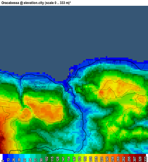
Below is the Elevation map of Oracabessa, which displays elevation range with different colors. Scale of the first map is from 0 to 333 m (0 to 1093 ft) with average elevation of 123.5 meters (=405 ft) [note 1]
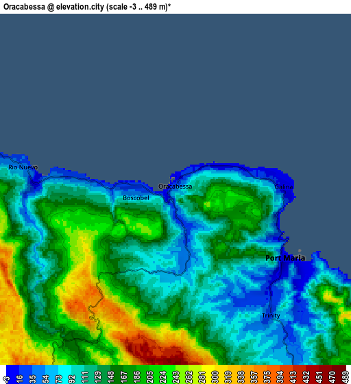
These maps also provides idea of topography and contour of this city, they are displayed at different zoom levels. More info about maps, scale and edge coordinates you can find below images.
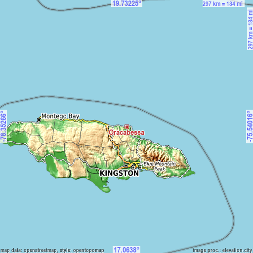
| \ | Map #1 | Map #2 | Topo.Map |
| Scale [m] | 0..333 m | -3..489 m | × |
| Scale [ft] | 0..1093 ft | -10..1604 ft | × |
| Average | 123.5 m = 405 ft | 154.7 m = 508 ft | × |
| Width | 9.27 km = 5.8 mi | 18.55 km = 11.5 mi | 296.7 km = 184.4 mi |
| Height | 9.27 km = 5.8 mi | 18.55 km = 11.5 mi | 296.7 km = 184.4 mi |
| ↑Max Latitude | 18.444883° | 18.486566° | 19.73225° |
| Latitude at center | 18.40319° | 18.40319° | 18.40319° |
| ↓Min Latitude | 18.361487° | 18.319774° | 17.0638° |
| ← Min Longitude | -76.990355° | -77.034301° | -78.35266° |
| Longitude center | -76.94641° | -76.94641° | -76.94641° |
| →Max Longitude | -76.902465° | -76.858519° | -75.54016° |
Nearby cities:
Cities around Oracabessa sort by population:
• Linstead elevation 119 m
31 km,  196°
196°
• Saint Ann’s Bay 14 m
27.1 km,  277°
277°
• Ewarton 226 m
28.5 km,  210°
210°
• Ocho Rios 42 m
16.5 km,  271°
271°
• Port Maria 2 m
7.1 km,  122°
122°
• Annotto Bay 5 m
24.1 km,  127°
127°
• Bamboo 628 m
33.6 km, 267°
• Riversdale 157 m
26.5 km,  184°
184°
• Moneague 360 m
22.5 km,  230°
230°
• Gayle 262 m
10.8 km,  218°
218°
• Islington 195 m
14.2 km,  137°
137°
• Richmond 191 m
17.6 km,  159°
159°
Multilingual:
 En español:
Oracabessa elevación 42 m.
 En France:
Oracabessa élévation 42 m.
 Auf Deutsch:
Oracabessa höhe über dem Meeresspiegel ist 42 m.

Sources and notes:
- [note 1] Map square and city borders are not equal. Map elevation data is calculated only from area inside that square.
- [src 1] Elevation data from geonames database provided with same terms of usage.
- [src 2] The elevation map of Oracabessa is generated using elevation data from NASA's 3 arcsec (90m) resolution SRTM data.
- [src 3] Base (background) map © OpenStreetMap contributors tiles are generated by Geofabrik and OpenTopoMap.
Copyright & License:
This Oracabessa Elevation Map is licensed under CC BY-SA. You may reuse any part from this page, if you give a proper credit by linking to this URL:
 More info on terms of use page.