Annotto Bay elevation
Annotto Bay (St. Mary), Jamaica elevation is 5 meters and Annotto Bay elevation in feet is 16 ft above sea level [src 1]. Annotto Bay is a populated place (feature code) with elevation that is 210 meters (689 ft) smaller than average city elevation in Jamaica.
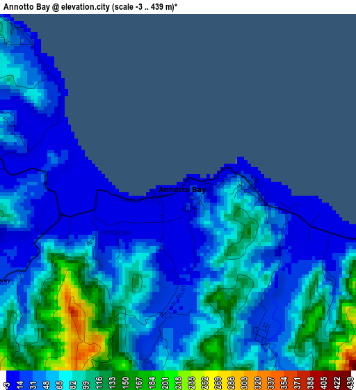
Below is the Elevation map of Annotto Bay, which displays elevation range with different colors. Scale of the first map is from -3 to 439 m (-10 to 1440 ft) with average elevation of 65.6 meters (=215 ft) [note 1]
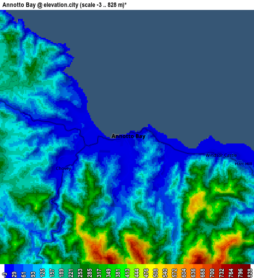
These maps also provides idea of topography and contour of this city, they are displayed at different zoom levels. More info about maps, scale and edge coordinates you can find below images.
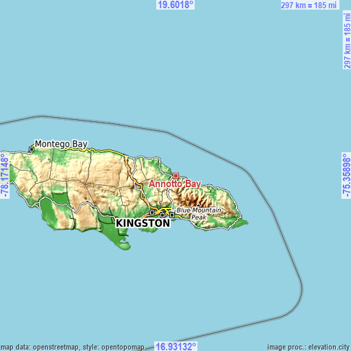
| \ | Map #1 | Map #2 | Topo.Map |
| Scale [m] | -3..439 m | -3..828 m | × |
| Scale [ft] | -10..1440 ft | -10..2717 ft | × |
| Average | 65.6 m = 215 ft | 179 m = 587 ft | × |
| Width | 9.28 km = 5.8 mi | 18.56 km = 11.5 mi | 296.9 km = 184.5 mi |
| Height | 9.28 km = 5.8 mi | 18.56 km = 11.5 mi | 297 km = 184.5 mi |
| ↑Max Latitude | 18.313425° | 18.355139° | 19.6018° |
| Latitude at center | 18.2717° | 18.2717° | 18.2717° |
| ↓Min Latitude | 18.229965° | 18.188221° | 16.93132° |
| ← Min Longitude | -76.809175° | -76.853121° | -78.17148° |
| Longitude center | -76.76523° | -76.76523° | -76.76523° |
| →Max Longitude | -76.721285° | -76.677339° | -75.35898° |
Nearby cities:
Cities around Annotto Bay sort by population:
• Constant Spring elevation 155 m
24.7 km,  186°
186°
• Stony Hill 544 m
21.5 km, 185°
• Port Maria 2 m
17 km,  309°
309°
• Oracabessa 42 m
24.1 km, 307°
• Riversdale 157 m
24.1 km,  240°
240°
• Gayle 262 m
26.5 km,  283°
283°
• Islington 195 m
10.3 km,  293°
293°
• Buff Bay 15 m
11.8 km,  111°
111°
• Richmond 191 m
13.1 km,  261°
261°
• Mavis Bank 933 m
28.5 km,  158°
158°
• Hope Bay 50 m
22.6 km, 111°
• Gordon Town 353 m
26.7 km,  169°
169°
Multilingual:
 En español:
Annotto Bay elevación 5 m.
 En France:
Annotto Bay élévation 5 m.
 Auf Deutsch:
Annotto Bay höhe über dem Meeresspiegel ist 5 m.

Sources and notes:
- [note 1] Map square and city borders are not equal. Map elevation data is calculated only from area inside that square.
- [src 1] Elevation data from geonames database provided with same terms of usage.
- [src 2] The elevation map of Annotto Bay is generated using elevation data from NASA's 3 arcsec (90m) resolution SRTM data.
- [src 3] Base (background) map © OpenStreetMap contributors tiles are generated by Geofabrik and OpenTopoMap.
Copyright & License:
This Annotto Bay Elevation Map is licensed under CC BY-SA. You may reuse any part from this page, if you give a proper credit by linking to this URL:
 More info on terms of use page.