San Zenone elevation
San Zenone (Lombardy, Provincia di Brescia), Italy elevation is 604 meters and San Zenone elevation in feet is 1982 ft above sea level [src 1]. San Zenone is a seat of a third-order administrative division (feature code) with elevation that is 282 meters (925 ft) bigger than average city elevation in Italy.
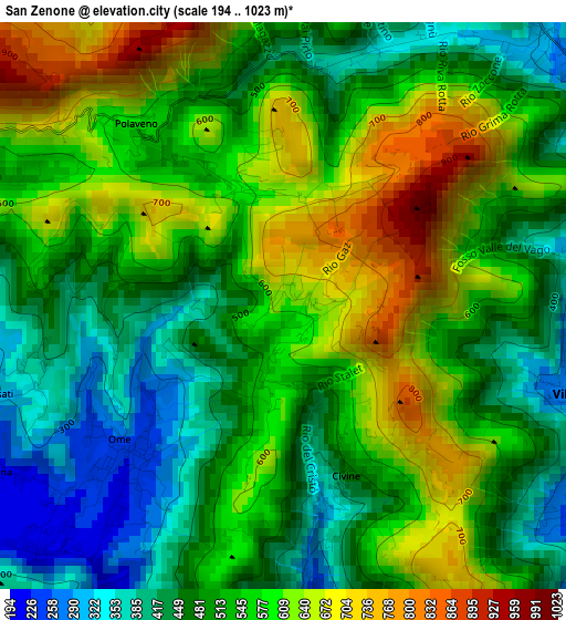
Below is the Elevation map of San Zenone, which displays elevation range with different colors. Scale of the first map is from 194 to 1023 m (636 to 3356 ft) with average elevation of 537.1 meters (=1762 ft) [note 1]
These maps also provides idea of topography and contour of this city, they are displayed at different zoom levels. More info about maps, scale and edge coordinates you can find below images.
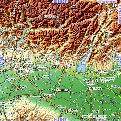
| \ | Map #1 | Topo.Map |
| Scale [m] | 194..1023 m | × |
| Scale [ft] | 636..3356 ft | × |
| Average | 537.1 m = 1762 ft | × |
| Width | 6.83 km = 4.2 mi | 218.6 km = 135.8 mi |
| Height | 6.83 km = 4.2 mi | 218.6 km = 135.8 mi |
| ↑Max Latitude | 45.672406° | 46.61624° |
| Latitude at center | 45.64169° | 45.64169° |
| ↓Min Latitude | 45.610958° | 44.64989° |
| ← Min Longitude | 10.102905° | 8.7406° |
| Longitude center | 10.14685° | 10.14685° |
| →Max Longitude | 10.190795° | 11.5531° |
Nearby cities:
Cities around San Zenone sort by population:
• Sarezzo elevation 275 m
4.4 km,  61°
61°
• Villa Carcina 242 m
3.9 km,  103°
103°
• Ponte Cingoli 175 m
5.8 km,  212°
212°
• Rodengo-Saiano 180 m
5.6 km, 213°
• Monticelli Brusati 285 m
3.7 km,  258°
258°
• San Vigilio 220 m
5.3 km,  135°
135°
• Parmezzana Calzana 272 m
4.1 km, 257°
• Ome 271 m
2.5 km,  231°
231°
• Polaveno 576 m
2.8 km,  321°
321°
• Ronco 169 m
5.1 km,  190°
190°
• Provezze 257 m
5.9 km, 258°
• Brione 640 m
0.1 km, 62°
Multilingual:
 En español:
San Zenone elevación 604 m.
 En France:
San Zenone élévation 604 m.
 Auf Deutsch:
San Zenone höhe über dem Meeresspiegel ist 604 m.

Sources and notes:
- [note 1] Map square and city borders are not equal. Map elevation data is calculated only from area inside that square.
- [src 1] Elevation data from geonames database provided with same terms of usage.
- [src 2] The elevation map of San Zenone is generated using elevation data from NASA's 3 arcsec (90m) resolution SRTM data.
- [src 3] Base (background) map © OpenStreetMap contributors tiles are generated by Geofabrik and OpenTopoMap.
Copyright & License:
This San Zenone Elevation Map is licensed under CC BY-SA. You may reuse any part from this page, if you give a proper credit by linking to this URL:
 More info on terms of use page.