Ronco elevation
Ronco (Lombardy, Provincia di Brescia), Italy elevation is 169 meters and Ronco elevation in feet is 554 ft above sea level [src 1]. Ronco is a populated place (feature code) with elevation that is 153 meters (502 ft) smaller than average city elevation in Italy.
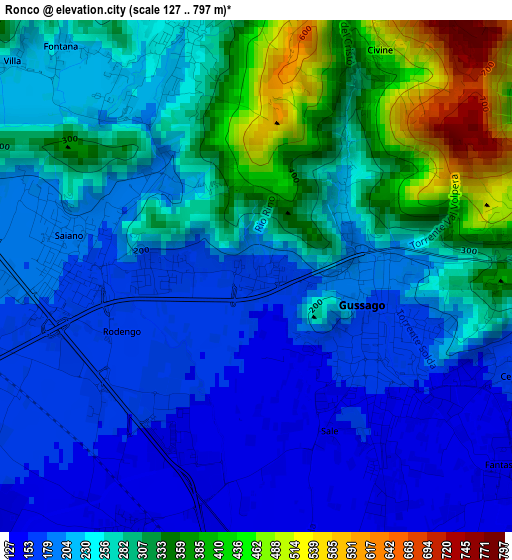
Below is the Elevation map of Ronco, which displays elevation range with different colors. Scale of the first map is from 127 to 797 m (417 to 2615 ft) with average elevation of 251.4 meters (=825 ft) [note 1]
These maps also provides idea of topography and contour of this city, they are displayed at different zoom levels. More info about maps, scale and edge coordinates you can find below images.
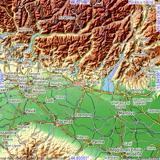
| \ | Map #1 | Topo.Map |
| Scale [m] | 127..797 m | × |
| Scale [ft] | 417..2615 ft | × |
| Average | 251.4 m = 825 ft | × |
| Width | 6.84 km = 4.3 mi | 218.8 km = 136 mi |
| Height | 6.84 km = 4.3 mi | 218.8 km = 136 mi |
| ↑Max Latitude | 45.626851° | 46.57146° |
| Latitude at center | 45.59611° | 45.59611° |
| ↓Min Latitude | 45.565353° | 44.60351° |
| ← Min Longitude | 10.091365° | 8.72906° |
| Longitude center | 10.13531° | 10.13531° |
| →Max Longitude | 10.179255° | 11.54156° |
Nearby cities:
Cities around Ronco sort by population:
• Gussago elevation 157 m
2.2 km,  129°
129°
• Piazza 163 m
1.8 km,  122°
122°
• Ponte Cingoli 175 m
2.2 km,  274°
274°
• Castegnato 142 m
4.2 km,  202°
202°
• Rodengo-Saiano 180 m
2.2 km,  279°
279°
• Passirano 198 m
5.1 km, 270°
• Cellatica 161 m
3.8 km,  114°
114°
• Paderno Franciacorta 177 m
4.4 km,  256°
256°
• San Vigilio 220 m
4.8 km,  73°
73°
• Ome 271 m
3.6 km,  342°
342°
• Fantasina 139 m
4.2 km, 127°
• San Zenone 604 m
5.1 km,  10°
10°
Multilingual:
 En español:
Ronco elevación 169 m.
 En France:
Ronco élévation 169 m.


Sources and notes:
- [note 1] Map square and city borders are not equal. Map elevation data is calculated only from area inside that square.
- [src 1] Elevation data from geonames database provided with same terms of usage.
- [src 2] The elevation map of Ronco is generated using elevation data from NASA's 3 arcsec (90m) resolution SRTM data.
- [src 3] Base (background) map © OpenStreetMap contributors tiles are generated by Geofabrik and OpenTopoMap.
Copyright & License:
This Ronco Elevation Map is licensed under CC BY-SA. You may reuse any part from this page, if you give a proper credit by linking to this URL:
 More info on terms of use page.