Brezza elevation
Brezza (Campania, Provincia di Caserta), Italy elevation is 16 meters and Brezza elevation in feet is 52 ft above sea level [src 1]. Brezza is a populated place (feature code) with elevation that is 306 meters (1004 ft) smaller than average city elevation in Italy.
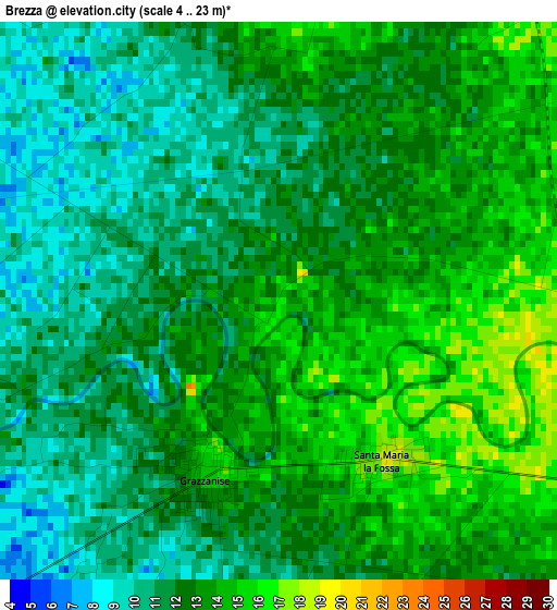
Below is the Elevation map of Brezza, which displays elevation range with different colors. Scale of the first map is from 4 to 23 m (13 to 75 ft) with average elevation of 12.1 meters (=40 ft) [note 1]
These maps also provides idea of topography and contour of this city, they are displayed at different zoom levels. More info about maps, scale and edge coordinates you can find below images.
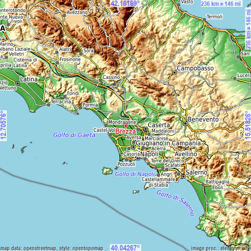
| \ | Map #1 | Topo.Map |
| Scale [m] | 4..23 m | × |
| Scale [ft] | 13..75 ft | × |
| Average | 12.1 m = 40 ft | × |
| Width | 7.36 km = 4.6 mi | 235.6 km = 146.4 mi |
| Height | 7.36 km = 4.6 mi | 235.6 km = 146.4 mi |
| ↑Max Latitude | 41.143832° | 42.16169° |
| Latitude at center | 41.11073° | 41.11073° |
| ↓Min Latitude | 41.077611° | 40.04267° |
| ← Min Longitude | 14.068065° | 12.70576° |
| Longitude center | 14.11201° | 14.11201° |
| →Max Longitude | 14.155955° | 15.51826° |
Nearby cities:
Cities around Brezza sort by population:
• Capua elevation 25 m
8.5 km,  94°
94°
• Sparanise 68 m
8.7 km,  351°
351°
• Vitulazio 60 m
10.3 km,  55°
55°
• Pignataro Maggiore 89 m
10.1 km,  28°
28°
• Grazzanise 14 m
2.6 km,  205°
205°
• Cancello-Arnone 10 m
8.4 km,  240°
240°
• Sant'Andrea-Pizzone-Ciamprisco 16 m
7.9 km,  303°
303°
• Pastorano 73 m
10.6 km,  42°
42°
• Santa Maria la Fossa 19 m
2.5 km,  147°
147°
• Nocelleto 45 m
10.5 km,  309°
309°
• Francolise 95 m
9.5 km,  330°
330°
• Cancello ed Arnone 10 m
8.3 km, 239°
Multilingual:
 En español:
Brezza elevación 16 m.
 En France:
Brezza élévation 16 m.


Sources and notes:
- [note 1] Map square and city borders are not equal. Map elevation data is calculated only from area inside that square.
- [src 1] Elevation data from geonames database provided with same terms of usage.
- [src 2] The elevation map of Brezza is generated using elevation data from NASA's 3 arcsec (90m) resolution SRTM data.
- [src 3] Base (background) map © OpenStreetMap contributors tiles are generated by Geofabrik and OpenTopoMap.
Copyright & License:
This Brezza Elevation Map is licensed under CC BY-SA. You may reuse any part from this page, if you give a proper credit by linking to this URL:
 More info on terms of use page.