San Lorenzo elevation
San Lorenzo (Campania, Provincia di Salerno), Italy elevation is 18 meters and San Lorenzo elevation in feet is 59 ft above sea level [src 1]. San Lorenzo is a populated place (feature code) with elevation that is 304 meters (997 ft) smaller than average city elevation in Italy.
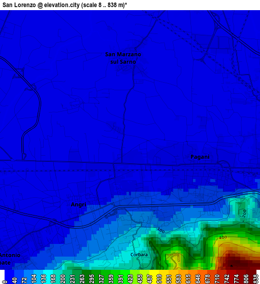
Below is the Elevation map of San Lorenzo, which displays elevation range with different colors. Scale of the first map is from 8 to 838 m (26 to 2749 ft) with average elevation of 58.2 meters (=191 ft) [note 1]
These maps also provides idea of topography and contour of this city, they are displayed at different zoom levels. More info about maps, scale and edge coordinates you can find below images.
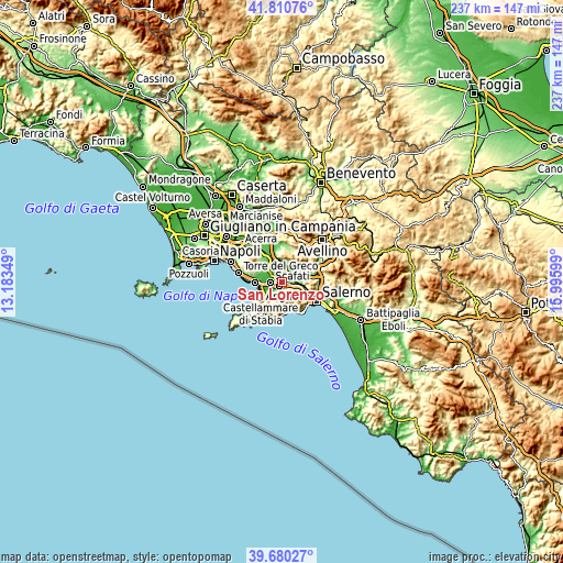
| \ | Map #1 | Topo.Map |
| Scale [m] | 8..838 m | × |
| Scale [ft] | 26..2749 ft | × |
| Average | 58.2 m = 191 ft | × |
| Width | 7.4 km = 4.6 mi | 236.9 km = 147.2 mi |
| Height | 7.4 km = 4.6 mi | 236.9 km = 147.2 mi |
| ↑Max Latitude | 40.787331° | 41.81076° |
| Latitude at center | 40.75405° | 40.75405° |
| ↓Min Latitude | 40.720752° | 39.68027° |
| ← Min Longitude | 14.545795° | 13.18349° |
| Longitude center | 14.58974° | 14.58974° |
| →Max Longitude | 14.633685° | 15.99599° |
Nearby cities:
Cities around San Lorenzo sort by population:
• Scafati elevation 16 m
4.5 km,  278°
278°
• Nocera Inferiore 49 m
4.8 km,  101°
101°
• Pagani 43 m
2.5 km,  122°
122°
• Angri 29 m
2.4 km,  222°
222°
• Sarno 24 m
6.5 km,  24°
24°
• Sant'Antonio Abate 17 m
5.5 km,  229°
229°
• San Marzano sul Sarno 15 m
2.8 km,  342°
342°
• San Valentino Torio 26 m
4.3 km, 15°
• Sant'Egidio del Monte Albino 51 m
1.8 km,  166°
166°
• Lettere 353 m
6.6 km,  214°
214°
• Corbara 186 m
3.5 km,  177°
177°
• Pietre 399 m
6.5 km,  156°
156°
Multilingual:
 En español:
San Lorenzo elevación 18 m.
 En France:
San Lorenzo élévation 18 m.
 Auf Deutsch:
San Lorenzo höhe über dem Meeresspiegel ist 18 m.

Sources and notes:
- [note 1] Map square and city borders are not equal. Map elevation data is calculated only from area inside that square.
- [src 1] Elevation data from geonames database provided with same terms of usage.
- [src 2] The elevation map of San Lorenzo is generated using elevation data from NASA's 3 arcsec (90m) resolution SRTM data.
- [src 3] Base (background) map © OpenStreetMap contributors tiles are generated by Geofabrik and OpenTopoMap.
Copyright & License:
This San Lorenzo Elevation Map is licensed under CC BY-SA. You may reuse any part from this page, if you give a proper credit by linking to this URL:
 More info on terms of use page.