Franche elevation
Franche (Campania, Napoli), Italy elevation is 390 meters and Franche elevation in feet is 1280 ft above sea level [src 1]. Franche is a populated place (feature code) with elevation that is 68 meters (223 ft) bigger than average city elevation in Italy.
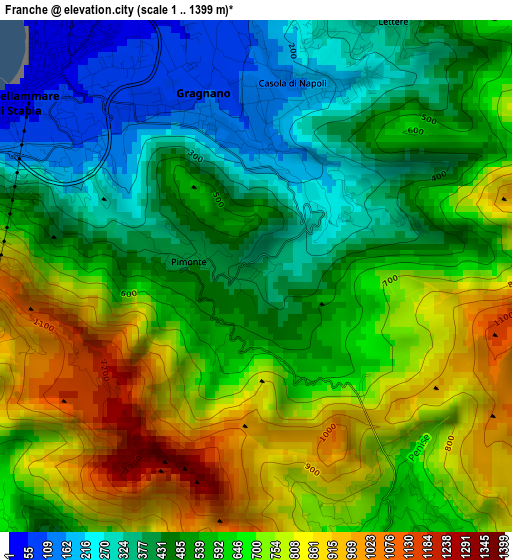
Below is the Elevation map of Franche, which displays elevation range with different colors. Scale of the first map is from 1 to 1399 m (3 to 4590 ft) with average elevation of 591.3 meters (=1940 ft) [note 1]
These maps also provides idea of topography and contour of this city, they are displayed at different zoom levels. More info about maps, scale and edge coordinates you can find below images.
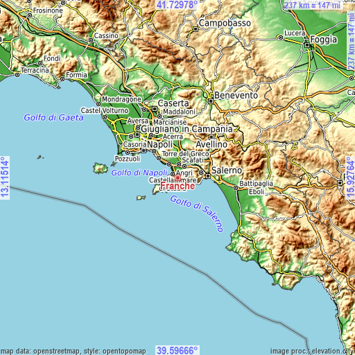
| \ | Map #1 | Topo.Map |
| Scale [m] | 1..1399 m | × |
| Scale [ft] | 3..4590 ft | × |
| Average | 591.3 m = 1940 ft | × |
| Width | 7.41 km = 4.6 mi | 237.2 km = 147.4 mi |
| Height | 7.41 km = 4.6 mi | 237.2 km = 147.4 mi |
| ↑Max Latitude | 40.705072° | 41.72978° |
| Latitude at center | 40.67175° | 40.67175° |
| ↓Min Latitude | 40.638411° | 39.59666° |
| ← Min Longitude | 14.477445° | 13.11514° |
| Longitude center | 14.52139° | 14.52139° |
| →Max Longitude | 14.565335° | 15.92764° |
Nearby cities:
Cities around Franche sort by population:
• Castellammare di Stabia elevation 19 m
4.5 km,  319°
319°
• Gragnano 124 m
1.9 km,  357°
357°
• Sant'Antonio Abate 17 m
5.8 km,  15°
15°
• Santa Maria La Carità 30 m
5 km,  348°
348°
• Agerola 670 m
4.1 km,  158°
158°
• Pianillo 585 m
4.8 km,  150°
150°
• Pimonte 415 m
1 km,  281°
281°
• Lettere 353 m
4.2 km,  28°
28°
• Piazza-Tralia-Pendolo 433 m
1.4 km, 277°
• Piazza Roma 337 m
4.1 km, 26°
• Casola di Napoli 178 m
3 km,  14°
14°
• Moiano 503 m
5.2 km,  244°
244°
Multilingual:
 En español:
Franche elevación 390 m.
 En France:
Franche élévation 390 m.


Sources and notes:
- [note 1] Map square and city borders are not equal. Map elevation data is calculated only from area inside that square.
- [src 1] Elevation data from geonames database provided with same terms of usage.
- [src 2] The elevation map of Franche is generated using elevation data from NASA's 3 arcsec (90m) resolution SRTM data.
- [src 3] Base (background) map © OpenStreetMap contributors tiles are generated by Geofabrik and OpenTopoMap.
Copyright & License:
This Franche Elevation Map is licensed under CC BY-SA. You may reuse any part from this page, if you give a proper credit by linking to this URL:
 More info on terms of use page.