Vadue elevation
Vadue (Calabria, Provincia di Cosenza), Italy elevation is 336 meters and Vadue elevation in feet is 1102 ft above sea level [src 1]. Vadue is a populated place (feature code) with elevation that is 14 meters (46 ft) bigger than average city elevation in Italy.
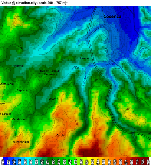
Below is the Elevation map of Vadue, which displays elevation range with different colors. Scale of the first map is from 200 to 757 m (656 to 2484 ft) with average elevation of 404 meters (=1325 ft) [note 1]
These maps also provides idea of topography and contour of this city, they are displayed at different zoom levels. More info about maps, scale and edge coordinates you can find below images.
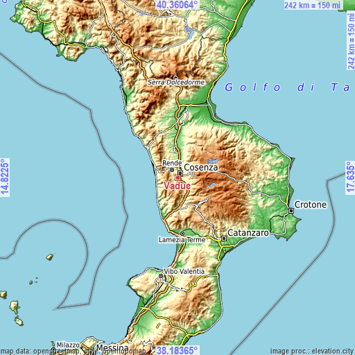
| \ | Map #1 | Topo.Map |
| Scale [m] | 200..757 m | × |
| Scale [ft] | 656..2484 ft | × |
| Average | 404 m = 1325 ft | × |
| Width | 7.56 km = 4.7 mi | 242.1 km = 150.4 mi |
| Height | 7.56 km = 4.7 mi | 242.1 km = 150.4 mi |
| ↑Max Latitude | 39.314608° | 40.36064° |
| Latitude at center | 39.2806° | 39.2806° |
| ↓Min Latitude | 39.246576° | 38.18365° |
| ← Min Longitude | 16.184805° | 14.8225° |
| Longitude center | 16.22875° | 16.22875° |
| →Max Longitude | 16.272695° | 17.635° |
Nearby cities:
Cities around Vadue sort by population:
• Cosenza elevation 245 m
2.9 km,  45°
45°
• Andreotta 300 m
3.1 km,  342°
342°
• Tivolille Pasquali-Merenzata 422 m
1.8 km,  266°
266°
• Marano Principato 512 m
5.1 km,  292°
292°
• Cerisano 588 m
4.5 km, 265°
• Laurignano 427 m
1.2 km,  97°
97°
• Mendicino 428 m
3.5 km,  236°
236°
• Surdo 257 m
5.7 km, 335°
• Carolei 622 m
3 km,  195°
195°
• Dipignano 724 m
5.1 km,  156°
156°
• Rosario 343 m
1.2 km,  10°
10°
• Castrolibero 513 m
4.4 km,  318°
318°
Multilingual:
 En español:
Vadue elevación 336 m.
 En France:
Vadue élévation 336 m.


Sources and notes:
- [note 1] Map square and city borders are not equal. Map elevation data is calculated only from area inside that square.
- [src 1] Elevation data from geonames database provided with same terms of usage.
- [src 2] The elevation map of Vadue is generated using elevation data from NASA's 3 arcsec (90m) resolution SRTM data.
- [src 3] Base (background) map © OpenStreetMap contributors tiles are generated by Geofabrik and OpenTopoMap.
Copyright & License:
This Vadue Elevation Map is licensed under CC BY-SA. You may reuse any part from this page, if you give a proper credit by linking to this URL:
 More info on terms of use page.