Dipignano elevation
Dipignano (Calabria, Provincia di Cosenza), Italy elevation is 724 meters and Dipignano elevation in feet is 2375 ft above sea level [src 1]. Dipignano is a seat of a third-order administrative division (feature code) with elevation that is 402 meters (1319 ft) bigger than average city elevation in Italy.
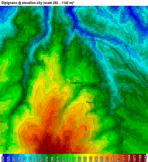
Below is the Elevation map of Dipignano, which displays elevation range with different colors. Scale of the first map is from 292 to 1142 m (958 to 3747 ft) with average elevation of 636.3 meters (=2088 ft) [note 1]
These maps also provides idea of topography and contour of this city, they are displayed at different zoom levels. More info about maps, scale and edge coordinates you can find below images.
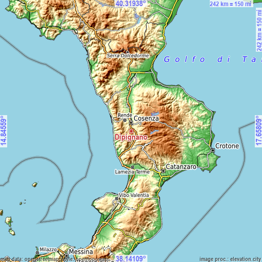
| \ | Map #1 | Topo.Map |
| Scale [m] | 292..1142 m | × |
| Scale [ft] | 958..3747 ft | × |
| Average | 636.3 m = 2088 ft | × |
| Width | 7.57 km = 4.7 mi | 242.2 km = 150.5 mi |
| Height | 7.57 km = 4.7 mi | 242.2 km = 150.5 mi |
| ↑Max Latitude | 39.272718° | 40.31938° |
| Latitude at center | 39.23869° | 39.23869° |
| ↓Min Latitude | 39.204645° | 38.14109° |
| ← Min Longitude | 16.207895° | 14.84559° |
| Longitude center | 16.25184° | 16.25184° |
| →Max Longitude | 16.295785° | 17.65809° |
Nearby cities:
Cities around Dipignano sort by population:
• Cosenza elevation 245 m
6.7 km,  0°
0°
• Tivolille Pasquali-Merenzata 422 m
5.9 km,  319°
319°
• Laurignano 427 m
4.6 km,  349°
349°
• Mendicino 428 m
5.6 km,  298°
298°
• Vadue 336 m
5.1 km,  336°
336°
• Carolei 622 m
3.3 km, 302°
• Piane Crati 589 m
6.2 km,  94°
94°
• Donnici Inferiore 490 m
3.8 km,  70°
70°
• Rosario 343 m
6.1 km, 343°
• Figline Vegliaturo 691 m
6.9 km,  102°
102°
• Paterno Calabro 674 m
1.6 km,  135°
135°
• Domanico 749 m
4.5 km,  237°
237°
Multilingual:
 En español:
Dipignano elevación 724 m.
 En France:
Dipignano élévation 724 m.
 Auf Deutsch:
Dipignano höhe über dem Meeresspiegel ist 724 m.

Sources and notes:
- [note 1] Map square and city borders are not equal. Map elevation data is calculated only from area inside that square.
- [src 1] Elevation data from geonames database provided with same terms of usage.
- [src 2] The elevation map of Dipignano is generated using elevation data from NASA's 3 arcsec (90m) resolution SRTM data.
- [src 3] Base (background) map © OpenStreetMap contributors tiles are generated by Geofabrik and OpenTopoMap.
Copyright & License:
This Dipignano Elevation Map is licensed under CC BY-SA. You may reuse any part from this page, if you give a proper credit by linking to this URL:
 More info on terms of use page.