Rettifilo-Vannullo elevation
Rettifilo-Vannullo (Campania, Provincia di Salerno), Italy elevation is 31 meters and Rettifilo-Vannullo elevation in feet is 102 ft above sea level [src 1]. Rettifilo-Vannullo is a populated place (feature code) with elevation that is 291 meters (955 ft) smaller than average city elevation in Italy.
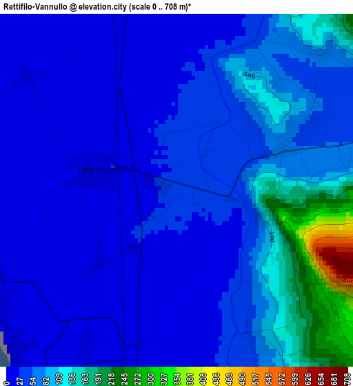
Below is the Elevation map of Rettifilo-Vannullo, which displays elevation range with different colors. Scale of the first map is from 0 to 708 m (0 to 2323 ft) with average elevation of 61.3 meters (=201 ft) [note 1]
These maps also provides idea of topography and contour of this city, they are displayed at different zoom levels. More info about maps, scale and edge coordinates you can find below images.
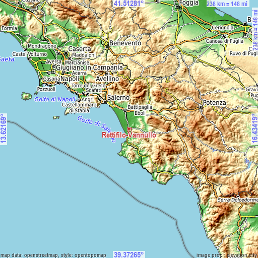
| \ | Map #1 | Topo.Map |
| Scale [m] | 0..708 m | × |
| Scale [ft] | 0..2323 ft | × |
| Average | 61.3 m = 201 ft | × |
| Width | 7.44 km = 4.6 mi | 238 km = 147.9 mi |
| Height | 7.44 km = 4.6 mi | 238 km = 147.9 mi |
| ↑Max Latitude | 40.484682° | 41.51281° |
| Latitude at center | 40.45125° | 40.45125° |
| ↓Min Latitude | 40.417801° | 39.37265° |
| ← Min Longitude | 14.983995° | 13.62169° |
| Longitude center | 15.02794° | 15.02794° |
| →Max Longitude | 15.071885° | 16.43419° |
Nearby cities:
Cities around Rettifilo-Vannullo sort by population:
• Agropoli elevation 21 m
11.8 km,  195°
195°
• Capaccio Scalo 21 m
1.7 km,  285°
285°
• Licinella-Torre di Paestum 9 m
5.6 km,  207°
207°
• Bivio Santa Cecilia 19 m
8.2 km,  343°
343°
• Matinella 40 m
6.5 km,  30°
30°
• Capaccio 407 m
5.3 km,  124°
124°
• Ogliastro Cilento 324 m
11.2 km,  172°
172°
• Laura 3 m
3.9 km,  237°
237°
• Trentinara 567 m
9.3 km,  127°
127°
• Albanella 223 m
8 km,  66°
66°
• Altavilla Silentina 316 m
12.4 km,  44°
44°
• Giungano 232 m
9.3 km, 132°
Multilingual:
 En español:
Rettifilo-Vannullo elevación 31 m.
 En France:
Rettifilo-Vannullo élévation 31 m.
 Auf Deutsch:
Rettifilo-Vannullo höhe über dem Meeresspiegel ist 31 m.

Sources and notes:
- [note 1] Map square and city borders are not equal. Map elevation data is calculated only from area inside that square.
- [src 1] Elevation data from geonames database provided with same terms of usage.
- [src 2] The elevation map of Rettifilo-Vannullo is generated using elevation data from NASA's 3 arcsec (90m) resolution SRTM data.
- [src 3] Base (background) map © OpenStreetMap contributors tiles are generated by Geofabrik and OpenTopoMap.
Copyright & License:
This Rettifilo-Vannullo Elevation Map is licensed under CC BY-SA. You may reuse any part from this page, if you give a proper credit by linking to this URL:
 More info on terms of use page.