Pianura Vomano elevation
Pianura Vomano (Abruzzo, Provincia di Teramo), Italy elevation is 56 meters and Pianura Vomano elevation in feet is 184 ft above sea level [src 1]. Pianura Vomano is a populated place (feature code) with elevation that is 266 meters (873 ft) smaller than average city elevation in Italy.
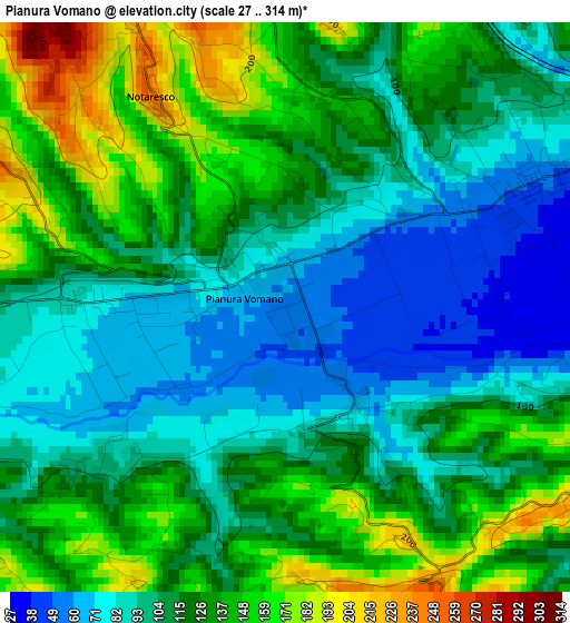
Below is the Elevation map of Pianura Vomano, which displays elevation range with different colors. Scale of the first map is from 27 to 314 m (89 to 1030 ft) with average elevation of 116.5 meters (=382 ft) [note 1]
These maps also provides idea of topography and contour of this city, they are displayed at different zoom levels. More info about maps, scale and edge coordinates you can find below images.
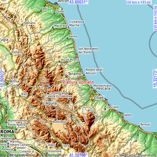
| \ | Map #1 | Topo.Map |
| Scale [m] | 27..314 m | × |
| Scale [ft] | 89..1030 ft | × |
| Average | 116.5 m = 382 ft | × |
| Width | 7.19 km = 4.5 mi | 230.1 km = 143 mi |
| Height | 7.19 km = 4.5 mi | 230.1 km = 143 mi |
| ↑Max Latitude | 42.662604° | 43.65631° |
| Latitude at center | 42.63028° | 42.63028° |
| ↓Min Latitude | 42.597939° | 41.58706° |
| ← Min Longitude | 13.871535° | 12.50923° |
| Longitude center | 13.91548° | 13.91548° |
| →Max Longitude | 13.959425° | 15.32173° |
Nearby cities:
Cities around Pianura Vomano sort by population:
• Roseto degli Abruzzi elevation 7 m
9.3 km,  60°
60°
• Atri 414 m
8.5 km,  134°
134°
• Castelnuovo Vomano 114 m
5.4 km,  268°
268°
• Notaresco 241 m
3.5 km,  330°
330°
• Scerne 5 m
10.2 km,  79°
79°
• Pagliare 51 m
3.3 km, 63°
• Casoli 184 m
5.4 km,  105°
105°
• Cellino Attanasio 411 m
6.7 km,  222°
222°
• Canzano 452 m
9.3 km,  280°
280°
• Castellalto 402 m
9.3 km,  303°
303°
• Morro d'Oro 208 m
3.7 km,  7°
7°
• Montefino 359 m
9.8 km,  194°
194°
Multilingual:
 En español:
Pianura Vomano elevación 56 m.
 En France:
Pianura Vomano élévation 56 m.
 Auf Deutsch:
Pianura Vomano höhe über dem Meeresspiegel ist 56 m.

Sources and notes:
- [note 1] Map square and city borders are not equal. Map elevation data is calculated only from area inside that square.
- [src 1] Elevation data from geonames database provided with same terms of usage.
- [src 2] The elevation map of Pianura Vomano is generated using elevation data from NASA's 3 arcsec (90m) resolution SRTM data.
- [src 3] Base (background) map © OpenStreetMap contributors tiles are generated by Geofabrik and OpenTopoMap.
Copyright & License:
This Pianura Vomano Elevation Map is licensed under CC BY-SA. You may reuse any part from this page, if you give a proper credit by linking to this URL:
 More info on terms of use page.