Atri elevation
Atri (Abruzzo, Provincia di Teramo), Italy elevation is 414 meters and Atri elevation in feet is 1358 ft above sea level [src 1]. Atri is a seat of a third-order administrative division (feature code) with elevation that is 92 meters (302 ft) bigger than average city elevation in Italy.
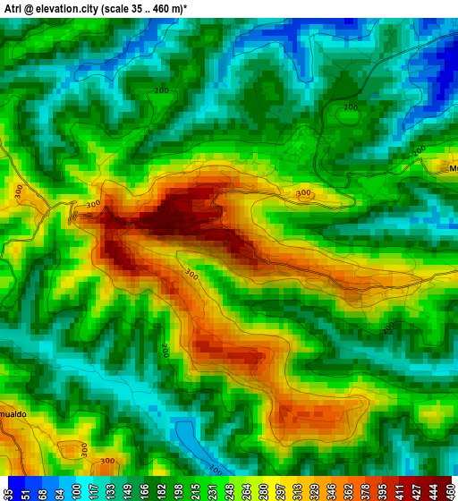
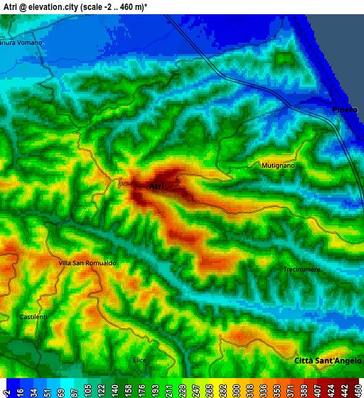
Below is the Elevation map of Atri, which displays elevation range with different colors. Scale of the first map is from 35 to 460 m (115 to 1509 ft) with average elevation of 215.8 meters (=708 ft) [note 1]
These maps also provides idea of topography and contour of this city, they are displayed at different zoom levels. More info about maps, scale and edge coordinates you can find below images.
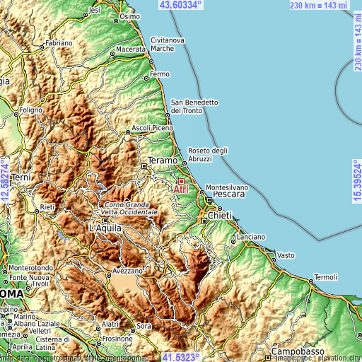
| \ | Map #1 | Map #2 | Topo.Map |
| Scale [m] | 35..460 m | -2..460 m | × |
| Scale [ft] | 115..1509 ft | -7..1509 ft | × |
| Average | 215.8 m = 708 ft | 165.3 m = 542 ft | × |
| Width | 7.2 km = 4.5 mi | 14.39 km = 8.9 mi | 230.3 km = 143.1 mi |
| Height | 7.2 km = 4.5 mi | 14.39 km = 8.9 mi | 230.3 km = 143.1 mi |
| ↑Max Latitude | 42.608772° | 42.641107° | 43.60334° |
| Latitude at center | 42.57642° | 42.57642° | 42.57642° |
| ↓Min Latitude | 42.544051° | 42.511666° | 41.5323° |
| ← Min Longitude | 13.945045° | 13.901099° | 12.58274° |
| Longitude center | 13.98899° | 13.98899° | 13.98899° |
| →Max Longitude | 14.032935° | 14.076881° | 15.39524° |
Nearby cities:
Cities around Atri sort by population:
• Pineto elevation 6 m
7.3 km,  60°
60°
• Borgo Santa Maria Immacolata 32 m
6.1 km,  49°
49°
• Città Sant'Angelo 184 m
9.3 km,  139°
139°
• Scerne 5 m
8.9 km,  26°
26°
• Pagliare 51 m
8.1 km,  337°
337°
• Pianura Vomano 56 m
8.5 km,  314°
314°
• Casoli 184 m
4.6 km,  349°
349°
• Cellino Attanasio 411 m
10.6 km,  275°
275°
• Castilenti 266 m
7.6 km,  230°
230°
• Castiglione Messer Raimondo 286 m
10.2 km,  241°
241°
• Elice 238 m
6.1 km,  194°
194°
• Montefino 359 m
9.2 km,  248°
248°
Multilingual:
 En español:
Atri elevación 414 m.
 En France:
Atri élévation 414 m.


Sources and notes:
- [note 1] Map square and city borders are not equal. Map elevation data is calculated only from area inside that square.
- [src 1] Elevation data from geonames database provided with same terms of usage.
- [src 2] The elevation map of Atri is generated using elevation data from NASA's 3 arcsec (90m) resolution SRTM data.
- [src 3] Base (background) map © OpenStreetMap contributors tiles are generated by Geofabrik and OpenTopoMap.
Copyright & License:
This Atri Elevation Map is licensed under CC BY-SA. You may reuse any part from this page, if you give a proper credit by linking to this URL:
 More info on terms of use page.