Cavino elevation
Cavino (Veneto, Provincia di Padova), Italy elevation is 19 meters and Cavino elevation in feet is 62 ft above sea level [src 1]. Cavino is a populated place (feature code) with elevation that is 303 meters (994 ft) smaller than average city elevation in Italy.
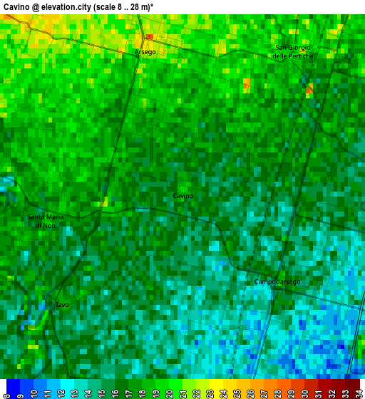
Below is the Elevation map of Cavino, which displays elevation range with different colors. Scale of the first map is from 8 to 28 m (26 to 92 ft) with average elevation of 16.4 meters (=54 ft) [note 1]
These maps also provides idea of topography and contour of this city, they are displayed at different zoom levels. More info about maps, scale and edge coordinates you can find below images.
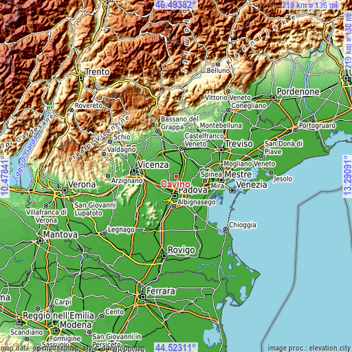
| \ | Map #1 | Topo.Map |
| Scale [m] | 8..28 m | × |
| Scale [ft] | 26..92 ft | × |
| Average | 16.4 m = 54 ft | × |
| Width | 6.85 km = 4.3 mi | 219.1 km = 136.1 mi |
| Height | 6.85 km = 4.3 mi | 219.1 km = 136.1 mi |
| ↑Max Latitude | 45.547874° | 46.49382° |
| Latitude at center | 45.51709° | 45.51709° |
| ↓Min Latitude | 45.486289° | 44.52311° |
| ← Min Longitude | 11.840715° | 10.47841° |
| Longitude center | 11.88466° | 11.88466° |
| →Max Longitude | 11.928605° | 13.29091° |
Nearby cities:
Cities around Cavino sort by population:
• Campodarsego elevation 13 m
3.6 km,  125°
125°
• Camposampiero 23 m
6.5 km,  37°
37°
• San Giorgio delle Pertiche 23 m
2.8 km,  15°
15°
• Borgoricco-San Michele delle Badesse-Sant'Eufemia 18 m
4.8 km,  65°
65°
• Limena 16 m
6.1 km,  209°
209°
• Campo San Martino 22 m
5.6 km,  308°
308°
• Pieve 21 m
5 km,  299°
299°
• Santa Maria di Non 18 m
2.5 km,  259°
259°
• Saletto 16 m
5.2 km,  201°
201°
• Tremignon 21 m
6.2 km,  273°
273°
• Curtarolo 17 m
3.8 km,  281°
281°
• Tavo 17 m
2.6 km,  225°
225°
Multilingual:
 En español:
Cavino elevación 19 m.
 En France:
Cavino élévation 19 m.


Sources and notes:
- [note 1] Map square and city borders are not equal. Map elevation data is calculated only from area inside that square.
- [src 1] Elevation data from geonames database provided with same terms of usage.
- [src 2] The elevation map of Cavino is generated using elevation data from NASA's 3 arcsec (90m) resolution SRTM data.
- [src 3] Base (background) map © OpenStreetMap contributors tiles are generated by Geofabrik and OpenTopoMap.
Copyright & License:
This Cavino Elevation Map is licensed under CC BY-SA. You may reuse any part from this page, if you give a proper credit by linking to this URL:
 More info on terms of use page.