Salvo Marina elevation
Salvo Marina (Abruzzo, Provincia di Chieti), Italy elevation is 4 meters and Salvo Marina elevation in feet is 13 ft above sea level [src 1]. Salvo Marina is a populated place (feature code) with elevation that is 318 meters (1043 ft) smaller than average city elevation in Italy.
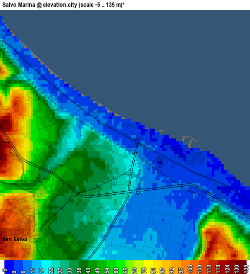
Below is the Elevation map of Salvo Marina, which displays elevation range with different colors. Scale of the first map is from -5 to 135 m (-16 to 443 ft) with average elevation of 35.8 meters (=117 ft) [note 1]
These maps also provides idea of topography and contour of this city, they are displayed at different zoom levels. More info about maps, scale and edge coordinates you can find below images.
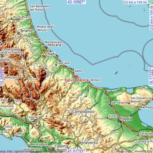
| \ | Map #1 | Topo.Map |
| Scale [m] | -5..135 m | × |
| Scale [ft] | -16..443 ft | × |
| Average | 35.8 m = 117 ft | × |
| Width | 7.25 km = 4.5 mi | 232.1 km = 144.2 mi |
| Height | 7.25 km = 4.5 mi | 232.1 km = 144.2 mi |
| ↑Max Latitude | 42.102983° | 43.10567° |
| Latitude at center | 42.07037° | 42.07037° |
| ↓Min Latitude | 42.03774° | 41.01791° |
| ← Min Longitude | 14.722025° | 13.35972° |
| Longitude center | 14.76597° | 14.76597° |
| →Max Longitude | 14.809915° | 16.17222° |
Nearby cities:
Cities around Salvo Marina sort by population:
• Vasto elevation 149 m
6.7 km,  312°
312°
• San Salvo 78 m
4 km,  222°
222°
• Montenero di Bisaccia 176 m
11.9 km,  173°
173°
• Cupello 282 m
7.9 km,  269°
269°
• Petacciato 230 m
10.4 km,  131°
131°
• Marina di Vasto 7 m
4.1 km, 308°
• Monteodorisio 267 m
9.4 km,  279°
279°
• Mafalda 444 m
14.7 km,  196°
196°
• Furci 552 m
16.3 km,  244°
244°
• Pollutri 184 m
16.2 km,  297°
297°
• Fresagrandinaria 387 m
13.3 km, 220°
• Lentella 386 m
11.1 km, 221°
Multilingual:
 En español:
Salvo Marina elevación 4 m.
 En France:
Salvo Marina élévation 4 m.
 Auf Deutsch:
Salvo Marina höhe über dem Meeresspiegel ist 4 m.

Sources and notes:
- [note 1] Map square and city borders are not equal. Map elevation data is calculated only from area inside that square.
- [src 1] Elevation data from geonames database provided with same terms of usage.
- [src 2] The elevation map of Salvo Marina is generated using elevation data from NASA's 3 arcsec (90m) resolution SRTM data.
- [src 3] Base (background) map © OpenStreetMap contributors tiles are generated by Geofabrik and OpenTopoMap.
Copyright & License:
This Salvo Marina Elevation Map is licensed under CC BY-SA. You may reuse any part from this page, if you give a proper credit by linking to this URL:
 More info on terms of use page.