Montelera elevation
Montelera (Piedmont, Torino), Italy elevation is 493 meters and Montelera elevation in feet is 1617 ft above sea level [src 1]. Montelera is a seat of a third-order administrative division (feature code) with elevation that is 171 meters (561 ft) bigger than average city elevation in Italy.
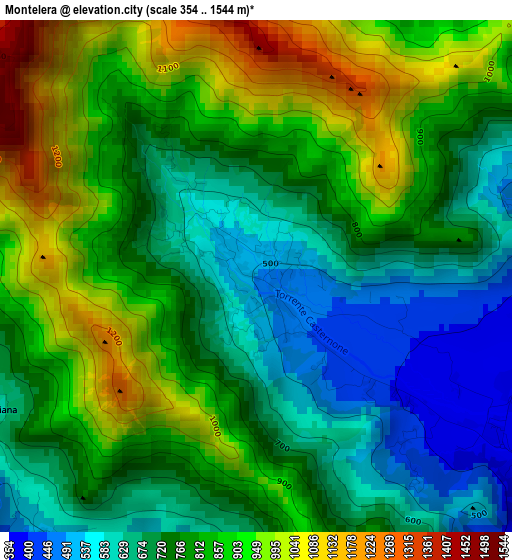
Below is the Elevation map of Montelera, which displays elevation range with different colors. Scale of the first map is from 354 to 1544 m (1161 to 5066 ft) with average elevation of 789.1 meters (=2589 ft) [note 1]
These maps also provides idea of topography and contour of this city, they are displayed at different zoom levels. More info about maps, scale and edge coordinates you can find below images.
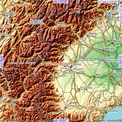
| \ | Map #1 | Topo.Map |
| Scale [m] | 354..1544 m | × |
| Scale [ft] | 1161..5066 ft | × |
| Average | 789.1 m = 2589 ft | × |
| Width | 6.89 km = 4.3 mi | 220.5 km = 137 mi |
| Height | 6.89 km = 4.3 mi | 220.5 km = 137 mi |
| ↑Max Latitude | 45.185272° | 46.13735° |
| Latitude at center | 45.15429° | 45.15429° |
| ↓Min Latitude | 45.123291° | 44.15397° |
| ← Min Longitude | 7.398955° | 6.03665° |
| Longitude center | 7.4429° | 7.4429° |
| →Max Longitude | 7.486845° | 8.84915° |
Nearby cities:
Cities around Montelera sort by population:
• Almese-Rivera elevation 421 m
5.1 km,  219°
219°
• Givoletto 440 m
4.3 km,  78°
78°
• Val della Torre 493 m
0.2 km,  59°
59°
• Caselette 373 m
6 km,  145°
145°
• Ferriera 339 m
7.9 km,  187°
187°
• San Gillio 322 m
7.2 km,  102°
102°
• Villar Dora 354 m
6.4 km,  226°
226°
• Drubiaglio-Grangia 339 m
6.8 km,  195°
195°
• Rubiana 612 m
5 km,  246°
246°
• La Cassa 375 m
6.4 km, 63°
• Milanere 341 m
5.6 km, 187°
• Varisella 547 m
6.8 km,  28°
28°
Multilingual:
 En español:
Montelera elevación 493 m.
 En France:
Montelera élévation 493 m.
 Auf Deutsch:
Montelera höhe über dem Meeresspiegel ist 493 m.

Sources and notes:
- [note 1] Map square and city borders are not equal. Map elevation data is calculated only from area inside that square.
- [src 1] Elevation data from geonames database provided with same terms of usage.
- [src 2] The elevation map of Montelera is generated using elevation data from NASA's 3 arcsec (90m) resolution SRTM data.
- [src 3] Base (background) map © OpenStreetMap contributors tiles are generated by Geofabrik and OpenTopoMap.
Copyright & License:
This Montelera Elevation Map is licensed under CC BY-SA. You may reuse any part from this page, if you give a proper credit by linking to this URL:
 More info on terms of use page.