Drubiaglio-Grangia elevation
Drubiaglio-Grangia (Piedmont, Torino), Italy elevation is 339 meters and Drubiaglio-Grangia elevation in feet is 1112 ft above sea level [src 1]. Drubiaglio-Grangia is a populated place (feature code) with elevation that is 17 meters (56 ft) bigger than average city elevation in Italy.
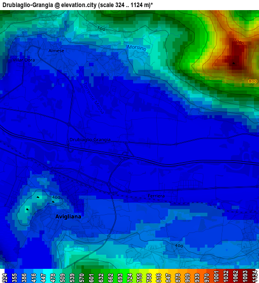
Below is the Elevation map of Drubiaglio-Grangia, which displays elevation range with different colors. Scale of the first map is from 324 to 1124 m (1063 to 3688 ft) with average elevation of 419.7 meters (=1377 ft) [note 1]
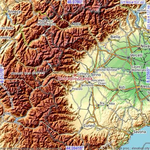
These maps also provides idea of topography and contour of this city, they are displayed at different zoom levels. More info about maps, scale and edge coordinates you can find below images.
| \ | Map #1 | Topo.Map |
| Scale [m] | 324..1124 m | × |
| Scale [ft] | 1063..3688 ft | × |
| Average | 419.7 m = 1377 ft | × |
| Width | 6.9 km = 4.3 mi | 220.8 km = 137.2 mi |
| Height | 6.9 km = 4.3 mi | 220.7 km = 137.1 mi |
| ↑Max Latitude | 45.126534° | 46.0796° |
| Latitude at center | 45.09552° | 45.09552° |
| ↓Min Latitude | 45.064489° | 44.09418° |
| ← Min Longitude | 7.375455° | 6.01315° |
| Longitude center | 7.4194° | 7.4194° |
| →Max Longitude | 7.463345° | 8.82565° |
Nearby cities:
Cities around Drubiaglio-Grangia sort by population:
• Avigliana elevation 400 m
2.5 km,  225°
225°
• Almese-Rivera 421 m
3 km,  331°
331°
• Sant'Ambrogio di Torino 354 m
4.2 km,  271°
271°
• Rosta 404 m
4.7 km,  130°
130°
• Buttigliera Alta 410 m
3.2 km,  161°
161°
• Caselette 373 m
5.4 km,  73°
73°
• Ferriera 339 m
1.6 km,  146°
146°
• Villar Dora 354 m
3.5 km,  307°
307°
• Rubiana 612 m
5.3 km, 328°
• Trana 375 m
6.3 km,  178°
178°
• Reano 453 m
4.9 km,  172°
172°
• Milanere 341 m
1.5 km,  48°
48°
Multilingual:
 En español:
Drubiaglio-Grangia elevación 339 m.
 En France:
Drubiaglio-Grangia élévation 339 m.
 Auf Deutsch:
Drubiaglio-Grangia höhe über dem Meeresspiegel ist 339 m.
 На русском:
Drubiaglio-Grangia высота над уровнем моря 339 м
Sources and notes:
- [note 1] Map square and city borders are not equal. Map elevation data is calculated only from area inside that square.
- [src 1] Elevation data from geonames database provided with same terms of usage.
- [src 2] The elevation map of Drubiaglio-Grangia is generated using elevation data from NASA's 3 arcsec (90m) resolution SRTM data.
- [src 3] Base (background) map © OpenStreetMap contributors tiles are generated by Geofabrik and OpenTopoMap.
Copyright & License:
This Drubiaglio-Grangia Elevation Map is licensed under CC BY-SA. You may reuse any part from this page, if you give a proper credit by linking to this URL:
 More info on terms of use page.