Mulino elevation
Mulino (Emilia-Romagna, Provincia di Modena), Italy elevation is 98 meters and Mulino elevation in feet is 322 ft above sea level [src 1]. Mulino is a populated place (feature code) with elevation that is 224 meters (735 ft) smaller than average city elevation in Italy.
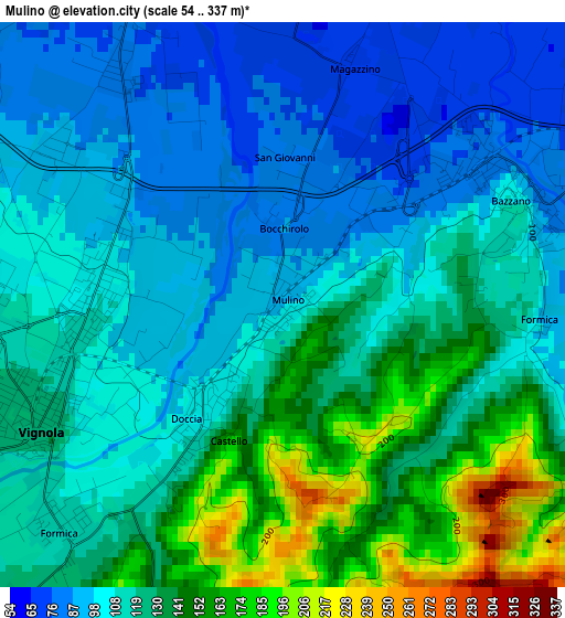
Below is the Elevation map of Mulino, which displays elevation range with different colors. Scale of the first map is from 54 to 337 m (177 to 1106 ft) with average elevation of 118.9 meters (=390 ft) [note 1]
These maps also provides idea of topography and contour of this city, they are displayed at different zoom levels. More info about maps, scale and edge coordinates you can find below images.
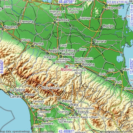
| \ | Map #1 | Topo.Map |
| Scale [m] | 54..337 m | × |
| Scale [ft] | 177..1106 ft | × |
| Average | 118.9 m = 390 ft | × |
| Width | 6.97 km = 4.3 mi | 223.1 km = 138.6 mi |
| Height | 6.97 km = 4.3 mi | 223.1 km = 138.6 mi |
| ↑Max Latitude | 44.52391° | 45.48708° |
| Latitude at center | 44.49257° | 44.49257° |
| ↓Min Latitude | 44.461214° | 43.48081° |
| ← Min Longitude | 11.002725° | 9.64042° |
| Longitude center | 11.04667° | 11.04667° |
| →Max Longitude | 11.090615° | 12.45292° |
Nearby cities:
Cities around Mulino sort by population:
• Vignola elevation 119 m
3 km,  251°
251°
• Spilamberto 69 m
5 km,  332°
332°
• Bazzano 88 m
3.3 km,  72°
72°
• Crespellano 65 m
7.1 km, 72°
• Piumazzo 58 m
6.2 km,  15°
15°
• Castelvetro di Modena 120 m
8 km,  279°
279°
• Marano sul Panaro 135 m
7.2 km,  239°
239°
• San Cesario sul Panaro 55 m
7.9 km,  353°
353°
• Savignano sul Panaro 105 m
1.6 km,  214°
214°
• Formica 111 m
3.8 km,  224°
224°
• Castelletto 185 m
6 km,  166°
166°
• Ca' di Sola 92 m
8.4 km,  299°
299°
Multilingual:
 En español:
Mulino elevación 98 m.
 En France:
Mulino élévation 98 m.


Sources and notes:
- [note 1] Map square and city borders are not equal. Map elevation data is calculated only from area inside that square.
- [src 1] Elevation data from geonames database provided with same terms of usage.
- [src 2] The elevation map of Mulino is generated using elevation data from NASA's 3 arcsec (90m) resolution SRTM data.
- [src 3] Base (background) map © OpenStreetMap contributors tiles are generated by Geofabrik and OpenTopoMap.
Copyright & License:
This Mulino Elevation Map is licensed under CC BY-SA. You may reuse any part from this page, if you give a proper credit by linking to this URL:
 More info on terms of use page.