Castelletto elevation
Castelletto (Emilia-Romagna, Bologna), Italy elevation is 185 meters and Castelletto elevation in feet is 607 ft above sea level [src 1]. Castelletto is a seat of a third-order administrative division (feature code) with elevation that is 137 meters (449 ft) smaller than average city elevation in Italy.
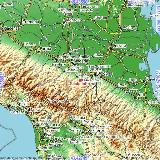
Below is the Elevation map of Castelletto, which displays elevation range with different colors. Scale of the first map is from 112 to 456 m (367 to 1496 ft) with average elevation of 226.7 meters (=744 ft) [note 1]
These maps also provides idea of topography and contour of this city, they are displayed at different zoom levels. More info about maps, scale and edge coordinates you can find below images.

| \ | Map #1 | Topo.Map |
| Scale [m] | 112..456 m | × |
| Scale [ft] | 367..1496 ft | × |
| Average | 226.7 m = 744 ft | × |
| Width | 6.98 km = 4.3 mi | 223.3 km = 138.8 mi |
| Height | 6.98 km = 4.3 mi | 223.3 km = 138.8 mi |
| ↑Max Latitude | 44.471518° | 45.43556° |
| Latitude at center | 44.44015° | 44.44015° |
| ↓Min Latitude | 44.408765° | 43.42749° |
| ← Min Longitude | 11.020835° | 9.65853° |
| Longitude center | 11.06478° | 11.06478° |
| →Max Longitude | 11.108725° | 12.47103° |
Nearby cities:
Cities around Castelletto sort by population:
• Vignola elevation 119 m
6.5 km,  318°
318°
• Spilamberto 69 m
11 km,  339°
339°
• Bazzano 88 m
7.1 km,  14°
14°
• Crespellano 65 m
9.6 km,  33°
33°
• Calderino 113 m
10.9 km,  79°
79°
• Marano sul Panaro 135 m
7.9 km,  285°
285°
• Savignano sul Panaro 105 m
5.1 km,  332°
332°
• Formica 111 m
5.1 km,  307°
307°
• Mulino 98 m
6 km,  346°
346°
• Guiglia 487 m
8.4 km,  257°
257°
• Monte San Giovanni 163 m
8.8 km,  104°
104°
• Savigno 264 m
5.4 km,  171°
171°
Multilingual:
 En español:
Castelletto elevación 185 m.
 En France:
Castelletto élévation 185 m.
 Auf Deutsch:
Castelletto höhe über dem Meeresspiegel ist 185 m.

Sources and notes:
- [note 1] Map square and city borders are not equal. Map elevation data is calculated only from area inside that square.
- [src 1] Elevation data from geonames database provided with same terms of usage.
- [src 2] The elevation map of Castelletto is generated using elevation data from NASA's 3 arcsec (90m) resolution SRTM data.
- [src 3] Base (background) map © OpenStreetMap contributors tiles are generated by Geofabrik and OpenTopoMap.
Copyright & License:
This Castelletto Elevation Map is licensed under CC BY-SA. You may reuse any part from this page, if you give a proper credit by linking to this URL:
 More info on terms of use page.