Montedecoro elevation
Montedecoro (Campania, Provincia di Caserta), Italy elevation is 50 meters and Montedecoro elevation in feet is 164 ft above sea level [src 1]. Montedecoro is a populated place (feature code) with elevation that is 272 meters (892 ft) smaller than average city elevation in Italy.
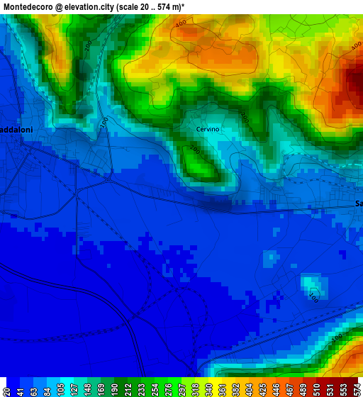
Below is the Elevation map of Montedecoro, which displays elevation range with different colors. Scale of the first map is from 20 to 574 m (66 to 1883 ft) with average elevation of 134.4 meters (=441 ft) [note 1]
These maps also provides idea of topography and contour of this city, they are displayed at different zoom levels. More info about maps, scale and edge coordinates you can find below images.
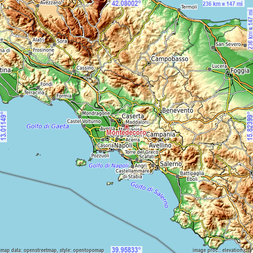
| \ | Map #1 | Topo.Map |
| Scale [m] | 20..574 m | × |
| Scale [ft] | 66..1883 ft | × |
| Average | 134.4 m = 441 ft | × |
| Width | 7.37 km = 4.6 mi | 235.9 km = 146.6 mi |
| Height | 7.37 km = 4.6 mi | 235.9 km = 146.6 mi |
| ↑Max Latitude | 41.060864° | 42.08002° |
| Latitude at center | 41.02772° | 41.02772° |
| ↓Min Latitude | 40.99456° | 39.95833° |
| ← Min Longitude | 14.373795° | 13.01149° |
| Longitude center | 14.41774° | 14.41774° |
| →Max Longitude | 14.461685° | 15.82399° |
Nearby cities:
Cities around Montedecoro sort by population:
• Caserta elevation 72 m
8.7 km,  304°
304°
• Maddaloni 59 m
3.1 km,  286°
286°
• San Nicola la Strada 56 m
7.6 km, 291°
• San Felice A Cancello 89 m
6 km,  101°
101°
• Santa Maria A Vico 75 m
4 km,  92°
92°
• Capodrise 32 m
9.5 km,  280°
280°
• San Marco Evangelista 48 m
6.6 km, 278°
• Arienzo 110 m
6.7 km, 90°
• Valle di Maddaloni 129 m
5.8 km,  0°
0°
• Cervino 126 m
1.5 km,  21°
21°
• Durazzano 288 m
4.7 km,  34°
34°
• Casola 340 m
8.1 km,  338°
338°
Multilingual:
 En español:
Montedecoro elevación 50 m.
 En France:
Montedecoro élévation 50 m.
 Auf Deutsch:
Montedecoro höhe über dem Meeresspiegel ist 50 m.

Sources and notes:
- [note 1] Map square and city borders are not equal. Map elevation data is calculated only from area inside that square.
- [src 1] Elevation data from geonames database provided with same terms of usage.
- [src 2] The elevation map of Montedecoro is generated using elevation data from NASA's 3 arcsec (90m) resolution SRTM data.
- [src 3] Base (background) map © OpenStreetMap contributors tiles are generated by Geofabrik and OpenTopoMap.
Copyright & License:
This Montedecoro Elevation Map is licensed under CC BY-SA. You may reuse any part from this page, if you give a proper credit by linking to this URL:
 More info on terms of use page.