San Nicola la Strada elevation
San Nicola la Strada (Campania, Provincia di Caserta), Italy elevation is 56 meters and San Nicola la Strada elevation in feet is 184 ft above sea level [src 1]. San Nicola la Strada is a seat of a third-order administrative division (feature code) with elevation that is 266 meters (873 ft) smaller than average city elevation in Italy.
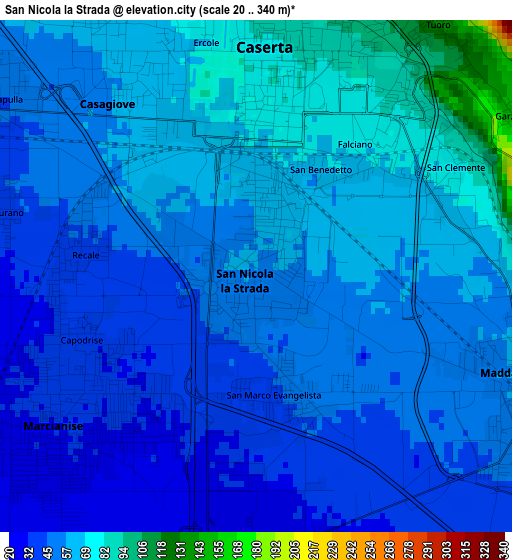
Below is the Elevation map of San Nicola la Strada, which displays elevation range with different colors. Scale of the first map is from 20 to 340 m (66 to 1115 ft) with average elevation of 54.5 meters (=179 ft) [note 1]
These maps also provides idea of topography and contour of this city, they are displayed at different zoom levels. More info about maps, scale and edge coordinates you can find below images.
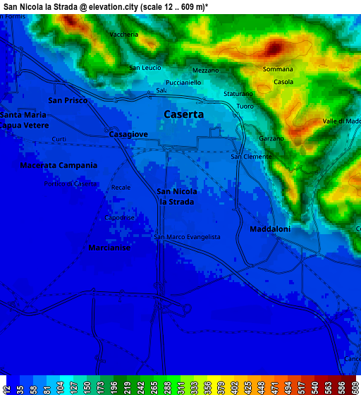
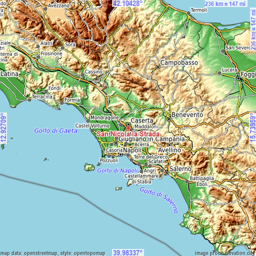
| \ | Map #1 | Map #2 | Topo.Map |
| Scale [m] | 20..340 m | 12..609 m | × |
| Scale [ft] | 66..1115 ft | 39..1998 ft | × |
| Average | 54.5 m = 179 ft | 101.7 m = 334 ft | × |
| Width | 7.37 km = 4.6 mi | 14.74 km = 9.2 mi | 235.8 km = 146.5 mi |
| Height | 7.37 km = 4.6 mi | 14.74 km = 9.2 mi | 235.8 km = 146.5 mi |
| ↑Max Latitude | 41.085501° | 41.118616° | 42.10428° |
| Latitude at center | 41.05237° | 41.05237° | 41.05237° |
| ↓Min Latitude | 41.019222° | 40.986057° | 39.98337° |
| ← Min Longitude | 14.289395° | 14.245449° | 12.92709° |
| Longitude center | 14.33334° | 14.33334° | 14.33334° |
| →Max Longitude | 14.377285° | 14.421231° | 15.73959° |
Nearby cities:
Cities around San Nicola la Strada sort by population:
• Caserta elevation 72 m
2.3 km,  357°
357°
• Marcianise 31 m
3.8 km,  230°
230°
• Maddaloni 59 m
4.5 km,  114°
114°
• Casagiove 58 m
2.8 km,  319°
319°
• San Prisco 47 m
6 km,  308°
308°
• Macerata Campania 38 m
4.8 km,  284°
284°
• Capodrise 32 m
2.5 km,  244°
244°
• Casapulla 47 m
4.6 km, 306°
• Recale 43 m
2.6 km, 281°
• Portico di Caserta 34 m
4.5 km,  274°
274°
• Curti 43 m
5.2 km,  300°
300°
• San Marco Evangelista 48 m
1.8 km,  162°
162°
Multilingual:
 En español:
San Nicola la Strada elevación 56 m.
 En France:
San Nicola la Strada élévation 56 m.
 Auf Deutsch:
San Nicola la Strada höhe über dem Meeresspiegel ist 56 m.
 На русском:
San Nicola la Strada высота над уровнем моря 56 м
Sources and notes:
- [note 1] Map square and city borders are not equal. Map elevation data is calculated only from area inside that square.
- [src 1] Elevation data from geonames database provided with same terms of usage.
- [src 2] The elevation map of San Nicola la Strada is generated using elevation data from NASA's 3 arcsec (90m) resolution SRTM data.
- [src 3] Base (background) map © OpenStreetMap contributors tiles are generated by Geofabrik and OpenTopoMap.
Copyright & License:
This San Nicola la Strada Elevation Map is licensed under CC BY-SA. You may reuse any part from this page, if you give a proper credit by linking to this URL:
 More info on terms of use page.