Roteglia elevation
Roteglia (Emilia-Romagna, Provincia di Reggio Emilia), Italy elevation is 185 meters and Roteglia elevation in feet is 607 ft above sea level [src 1]. Roteglia is a populated place (feature code) with elevation that is 137 meters (449 ft) smaller than average city elevation in Italy.
Below is the Elevation map of Roteglia, which displays elevation range with different colors. Scale of the first map is from 145 to 568 m (476 to 1864 ft) with average elevation of 289.9 meters (=951 ft) [note 1]
These maps also provides idea of topography and contour of this city, they are displayed at different zoom levels. More info about maps, scale and edge coordinates you can find below images.
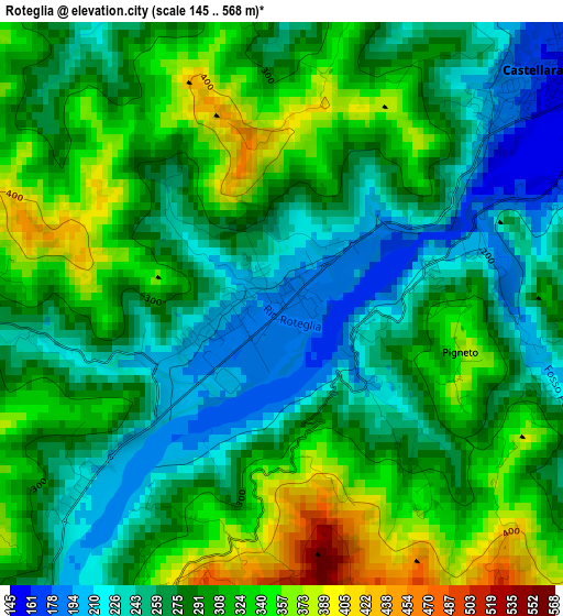
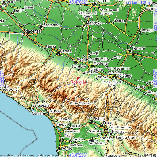
| \ | Map #1 | Topo.Map |
| Scale [m] | 145..568 m | × |
| Scale [ft] | 476..1864 ft | × |
| Average | 289.9 m = 951 ft | × |
| Width | 6.97 km = 4.3 mi | 223.1 km = 138.6 mi |
| Height | 6.97 km = 4.3 mi | 223.1 km = 138.6 mi |
| ↑Max Latitude | 44.515514° | 45.47882° |
| Latitude at center | 44.48417° | 44.48417° |
| ↓Min Latitude | 44.452809° | 43.47226° |
| ← Min Longitude | 10.644375° | 9.28207° |
| Longitude center | 10.68832° | 10.68832° |
| →Max Longitude | 10.732265° | 12.09457° |
Nearby cities:
Cities around Roteglia sort by population:
• Sassuolo elevation 123 m
10.1 km,  49°
49°
• Fiorano 125 m
11.5 km,  58°
58°
• Castellarano 146 m
5.4 km, 45°
• Casalgrande 108 m
11.8 km,  18°
18°
• Veggia-Villalunga 132 m
10.1 km,  32°
32°
• Prignano sulla Secchia 574 m
5.1 km,  176°
176°
• Serramazzoni 759 m
10.3 km,  127°
127°
• Ventoso 138 m
11.3 km,  359°
359°
• San Michele dei Mucchietti 179 m
5.4 km, 59°
• Viano 218 m
8.5 km,  323°
323°
• Baiso 534 m
7.1 km,  281°
281°
• Prignano 556 m
5.1 km, 177°
Multilingual:
 En español:
Roteglia elevación 185 m.
 En France:
Roteglia élévation 185 m.
 Auf Deutsch:
Roteglia höhe über dem Meeresspiegel ist 185 m.

Sources and notes:
- [note 1] Map square and city borders are not equal. Map elevation data is calculated only from area inside that square.
- [src 1] Elevation data from geonames database provided with same terms of usage.
- [src 2] The elevation map of Roteglia is generated using elevation data from NASA's 3 arcsec (90m) resolution SRTM data.
- [src 3] Base (background) map © OpenStreetMap contributors tiles are generated by Geofabrik and OpenTopoMap.
Copyright & License:
This Roteglia Elevation Map is licensed under CC BY-SA. You may reuse any part from this page, if you give a proper credit by linking to this URL:
 More info on terms of use page.