Serramazzoni elevation
Serramazzoni (Emilia-Romagna, Provincia di Modena), Italy elevation is 759 meters and Serramazzoni elevation in feet is 2490 ft above sea level [src 1]. Serramazzoni is a seat of a third-order administrative division (feature code) with elevation that is 437 meters (1434 ft) bigger than average city elevation in Italy.
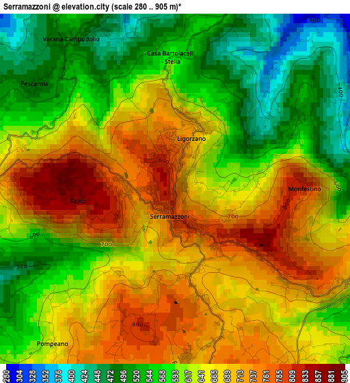
Below is the Elevation map of Serramazzoni, which displays elevation range with different colors. Scale of the first map is from 280 to 905 m (919 to 2969 ft) with average elevation of 630.8 meters (=2070 ft) [note 1]
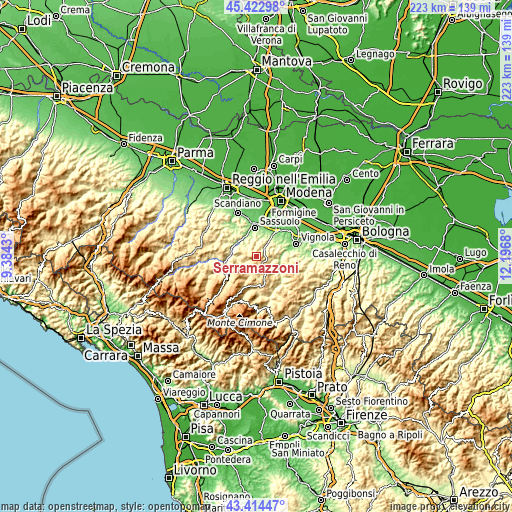
These maps also provides idea of topography and contour of this city, they are displayed at different zoom levels. More info about maps, scale and edge coordinates you can find below images.
| \ | Map #1 | Topo.Map |
| Scale [m] | 280..905 m | × |
| Scale [ft] | 919..2969 ft | × |
| Average | 630.8 m = 2070 ft | × |
| Width | 6.98 km = 4.3 mi | 223.3 km = 138.8 mi |
| Height | 6.98 km = 4.3 mi | 223.3 km = 138.8 mi |
| ↑Max Latitude | 44.458725° | 45.42298° |
| Latitude at center | 44.42735° | 44.42735° |
| ↓Min Latitude | 44.395959° | 43.41447° |
| ← Min Longitude | 10.746605° | 9.3843° |
| Longitude center | 10.79055° | 10.79055° |
| →Max Longitude | 10.834495° | 12.1968° |
Nearby cities:
Cities around Serramazzoni sort by population:
• Sassuolo elevation 123 m
12.9 km,  357°
357°
• Fiorano 125 m
12.5 km,  7°
7°
• Castellarano 146 m
11 km,  337°
337°
• Maranello 129 m
13.1 km,  28°
28°
• Pavullo nel Frignano 693 m
11 km,  161°
161°
• Prignano sulla Secchia 574 m
7.9 km,  278°
278°
• Roteglia 185 m
10.3 km,  307°
307°
• San Michele dei Mucchietti 179 m
9.7 km, 339°
• Gorzano 147 m
12.2 km,  35°
35°
• Sant'Antonio 710 m
7.7 km,  151°
151°
• Prignano 556 m
8 km, 278°
• Polinago 792 m
10.5 km,  209°
209°
Multilingual:
 En español:
Serramazzoni elevación 759 m.
 En France:
Serramazzoni élévation 759 m.
 Auf Deutsch:
Serramazzoni höhe über dem Meeresspiegel ist 759 m.

Sources and notes:
- [note 1] Map square and city borders are not equal. Map elevation data is calculated only from area inside that square.
- [src 1] Elevation data from geonames database provided with same terms of usage.
- [src 2] The elevation map of Serramazzoni is generated using elevation data from NASA's 3 arcsec (90m) resolution SRTM data.
- [src 3] Base (background) map © OpenStreetMap contributors tiles are generated by Geofabrik and OpenTopoMap.
Copyright & License:
This Serramazzoni Elevation Map is licensed under CC BY-SA. You may reuse any part from this page, if you give a proper credit by linking to this URL:
 More info on terms of use page.