Garino elevation
Garino (Piedmont, Torino), Italy elevation is 236 meters and Garino elevation in feet is 774 ft above sea level [src 1]. Garino is a populated place (feature code) with elevation that is 86 meters (282 ft) smaller than average city elevation in Italy.
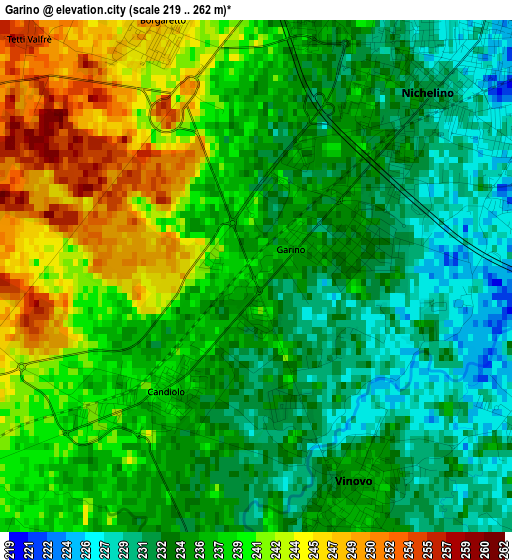
Below is the Elevation map of Garino, which displays elevation range with different colors. Scale of the first map is from 219 to 262 m (719 to 860 ft) with average elevation of 236.7 meters (=777 ft) [note 1]
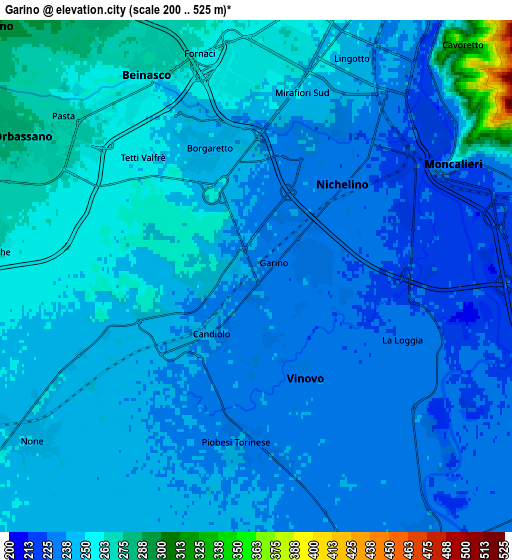
These maps also provides idea of topography and contour of this city, they are displayed at different zoom levels. More info about maps, scale and edge coordinates you can find below images.
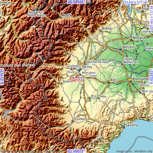
| \ | Map #1 | Map #2 | Topo.Map |
| Scale [m] | 219..262 m | 200..525 m | × |
| Scale [ft] | 719..860 ft | 656..1722 ft | × |
| Average | 236.7 m = 777 ft | 244.2 m = 801 ft | × |
| Width | 6.91 km = 4.3 mi | 13.83 km = 8.6 mi | 221.2 km = 137.4 mi |
| Height | 6.91 km = 4.3 mi | 13.83 km = 8.6 mi | 221.2 km = 137.4 mi |
| ↑Max Latitude | 45.00433° | 45.035393° | 45.95946° |
| Latitude at center | 44.97325° | 44.97325° | 44.97325° |
| ↓Min Latitude | 44.942153° | 44.911039° | 43.96979° |
| ← Min Longitude | 7.573335° | 7.529389° | 6.21103° |
| Longitude center | 7.61728° | 7.61728° | 7.61728° |
| →Max Longitude | 7.661225° | 7.705171° | 9.02353° |
Nearby cities:
Cities around Garino sort by population:
• Moncalieri elevation 236 m
5.9 km,  60°
60°
• Nichelino 227 m
4.1 km,  43°
43°
• Orbassano 272 m
7.2 km,  299°
299°
• Vinovo 234 m
3.2 km,  157°
157°
• La Loggia 229 m
4.5 km,  116°
116°
• Beinasco 263 m
6.2 km,  336°
336°
• Candiolo 240 m
2.2 km,  222°
222°
• Piobesi Torinese 237 m
4.5 km,  187°
187°
• Fornaci 263 m
6.3 km,  346°
346°
• Tagliaferro 226 m
3.7 km,  81°
81°
• Pasta 266 m
6.6 km,  309°
309°
• Borgo Melano 258 m
5.7 km,  325°
325°
Multilingual:
 En español:
Garino elevación 236 m.
 En France:
Garino élévation 236 m.


Sources and notes:
- [note 1] Map square and city borders are not equal. Map elevation data is calculated only from area inside that square.
- [src 1] Elevation data from geonames database provided with same terms of usage.
- [src 2] The elevation map of Garino is generated using elevation data from NASA's 3 arcsec (90m) resolution SRTM data.
- [src 3] Base (background) map © OpenStreetMap contributors tiles are generated by Geofabrik and OpenTopoMap.
Copyright & License:
This Garino Elevation Map is licensed under CC BY-SA. You may reuse any part from this page, if you give a proper credit by linking to this URL:
 More info on terms of use page.