Orbassano elevation
Orbassano (Piedmont, Torino), Italy elevation is 272 meters and Orbassano elevation in feet is 892 ft above sea level [src 1]. Orbassano is a seat of a third-order administrative division (feature code) with elevation that is 50 meters (164 ft) smaller than average city elevation in Italy.
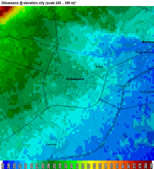
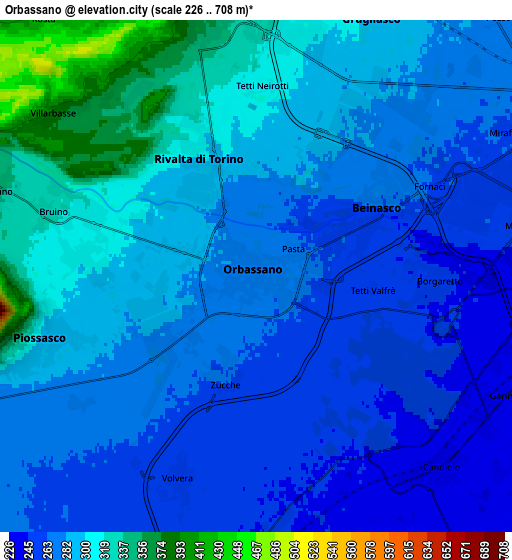
Below is the Elevation map of Orbassano, which displays elevation range with different colors. Scale of the first map is from 240 to 390 m (787 to 1280 ft) with average elevation of 272.2 meters (=893 ft) [note 1]
These maps also provides idea of topography and contour of this city, they are displayed at different zoom levels. More info about maps, scale and edge coordinates you can find below images.
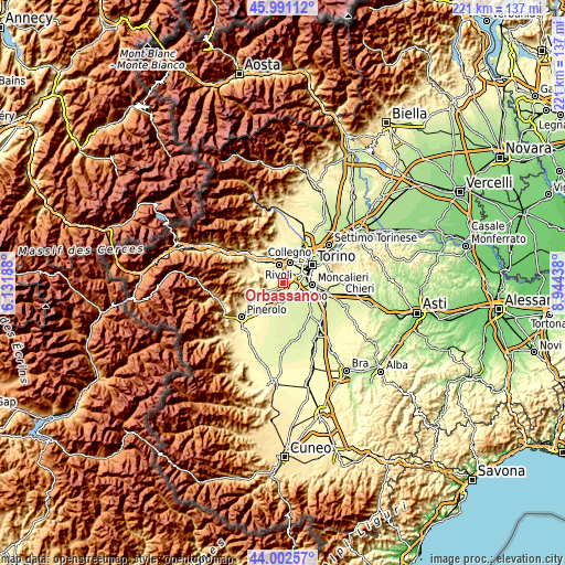
| \ | Map #1 | Map #2 | Topo.Map |
| Scale [m] | 240..390 m | 226..708 m | × |
| Scale [ft] | 787..1280 ft | 741..2323 ft | × |
| Average | 272.2 m = 893 ft | 284.8 m = 934 ft | × |
| Width | 6.91 km = 4.3 mi | 13.82 km = 8.6 mi | 221.1 km = 137.4 mi |
| Height | 6.91 km = 4.3 mi | 13.82 km = 8.6 mi | 221.1 km = 137.4 mi |
| ↑Max Latitude | 45.036533° | 45.067578° | 45.99112° |
| Latitude at center | 45.00547° | 45.00547° | 45.00547° |
| ↓Min Latitude | 44.974391° | 44.943294° | 44.00257° |
| ← Min Longitude | 7.494185° | 7.450239° | 6.13188° |
| Longitude center | 7.53813° | 7.53813° | 7.53813° |
| →Max Longitude | 7.582075° | 7.626021° | 8.94438° |
Nearby cities:
Cities around Orbassano sort by population:
• Piossasco elevation 310 m
6.4 km,  252°
252°
• Rivalta di Torino 295 m
3.3 km,  335°
335°
• Bruino 306 m
4.9 km,  282°
282°
• Beinasco 263 m
4.3 km,  60°
60°
• Gerbole 284 m
2.5 km,  258°
258°
• Volvera 255 m
6 km,  200°
200°
• Candiolo 240 m
7 km,  137°
137°
• Gerbole-Zucche 270 m
2.7 km,  217°
217°
• Fornaci 263 m
5.4 km, 62°
• Pasta 266 m
1.3 km, 59°
• Borgo Melano 258 m
3.2 km,  69°
69°
• Tetti Neirotti 312 m
5.3 km,  2°
2°
Multilingual:
 En español:
Orbassano elevación 272 m.
 En France:
Orbassano élévation 272 m.
 Auf Deutsch:
Orbassano höhe über dem Meeresspiegel ist 272 m.

Sources and notes:
- [note 1] Map square and city borders are not equal. Map elevation data is calculated only from area inside that square.
- [src 1] Elevation data from geonames database provided with same terms of usage.
- [src 2] The elevation map of Orbassano is generated using elevation data from NASA's 3 arcsec (90m) resolution SRTM data.
- [src 3] Base (background) map © OpenStreetMap contributors tiles are generated by Geofabrik and OpenTopoMap.
Copyright & License:
This Orbassano Elevation Map is licensed under CC BY-SA. You may reuse any part from this page, if you give a proper credit by linking to this URL:
 More info on terms of use page.