Eremo elevation
Eremo (Lombardy, Provincia di Mantova), Italy elevation is 24 meters and Eremo elevation in feet is 79 ft above sea level [src 1]. Eremo is a populated place (feature code) with elevation that is 298 meters (978 ft) smaller than average city elevation in Italy.
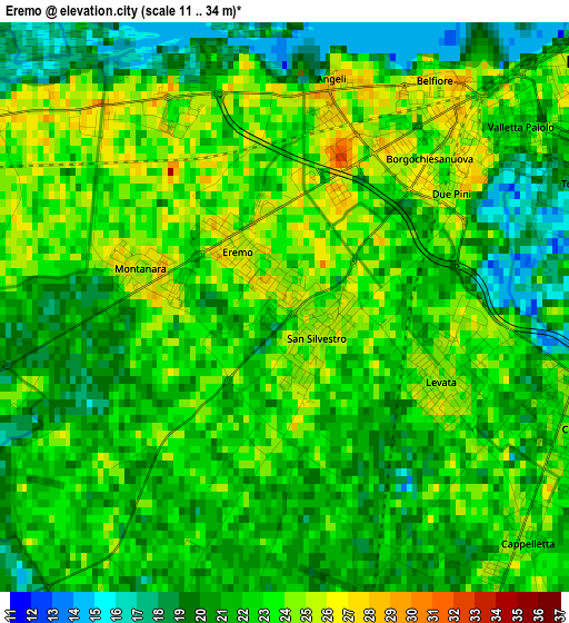
Below is the Elevation map of Eremo, which displays elevation range with different colors. Scale of the first map is from 11 to 34 m (36 to 112 ft) with average elevation of 21.8 meters (=72 ft) [note 1]
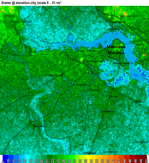
These maps also provides idea of topography and contour of this city, they are displayed at different zoom levels. More info about maps, scale and edge coordinates you can find below images.
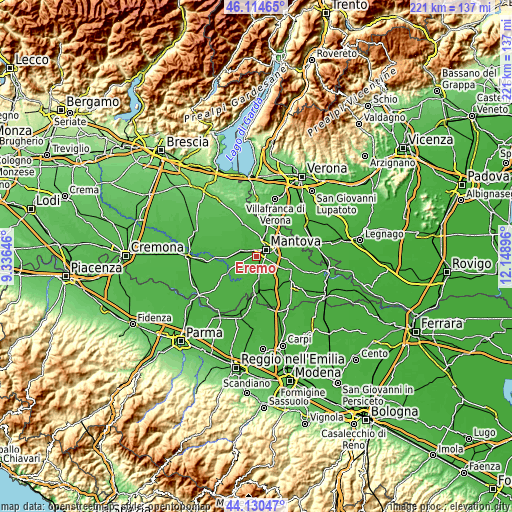
| \ | Map #1 | Map #2 | Topo.Map |
| Scale [m] | 11..34 m | 8..51 m | × |
| Scale [ft] | 36..112 ft | 26..167 ft | × |
| Average | 21.8 m = 72 ft | 20.5 m = 67 ft | × |
| Width | 6.89 km = 4.3 mi | 13.79 km = 8.6 mi | 220.6 km = 137.1 mi |
| Height | 6.89 km = 4.3 mi | 13.79 km = 8.6 mi | 220.6 km = 137.1 mi |
| ↑Max Latitude | 45.162184° | 45.193162° | 46.11465° |
| Latitude at center | 45.13119° | 45.13119° | 45.13119° |
| ↓Min Latitude | 45.100179° | 45.069151° | 44.13047° |
| ← Min Longitude | 10.698765° | 10.654819° | 9.33646° |
| Longitude center | 10.74271° | 10.74271° | 10.74271° |
| →Max Longitude | 10.786655° | 10.830601° | 12.14896° |
Nearby cities:
Cities around Eremo sort by population:
• Mantova elevation 29 m
5.4 km,  53°
53°
• Sant'Antonio 31 m
8.3 km,  28°
28°
• Mottella 25 m
8.8 km,  65°
65°
• Cerese 24 m
3.9 km,  111°
111°
• Lunetta-Frassino 26 m
6.9 km,  62°
62°
• Levata 24 m
2.1 km, 108°
• Castellucchio 26 m
7.7 km,  286°
286°
• Montanara 25 m
1.9 km,  283°
283°
• Buscoldo 22 m
5.5 km,  221°
221°
• Cappelletta 24 m
4 km,  135°
135°
• Soave 24 m
7.3 km,  348°
348°
• Borgoforte 22 m
8.8 km,  176°
176°
Multilingual:
 En español:
Eremo elevación 24 m.
 En France:
Eremo élévation 24 m.


Sources and notes:
- [note 1] Map square and city borders are not equal. Map elevation data is calculated only from area inside that square.
- [src 1] Elevation data from geonames database provided with same terms of usage.
- [src 2] The elevation map of Eremo is generated using elevation data from NASA's 3 arcsec (90m) resolution SRTM data.
- [src 3] Base (background) map © OpenStreetMap contributors tiles are generated by Geofabrik and OpenTopoMap.
Copyright & License:
This Eremo Elevation Map is licensed under CC BY-SA. You may reuse any part from this page, if you give a proper credit by linking to this URL:
 More info on terms of use page.