Mantova elevation
Mantova (Lombardy, Provincia di Mantova), Italy elevation is 29 meters and Mantova elevation in feet is 95 ft above sea level [src 1]. Mantova is a seat of a second-order administrative division (feature code) with elevation that is 293 meters (961 ft) smaller than average city elevation in Italy.
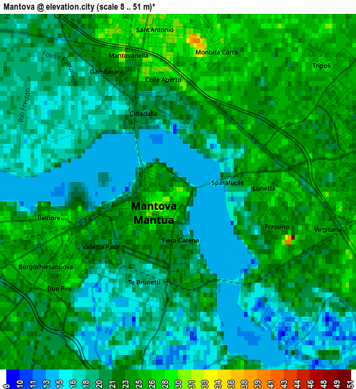
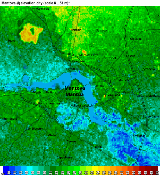
Below is the Elevation map of Mantova, which displays elevation range with different colors. Scale of the first map is from 8 to 51 m (26 to 167 ft) with average elevation of 21 meters (=69 ft) [note 1]
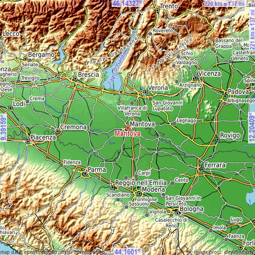
These maps also provides idea of topography and contour of this city, they are displayed at different zoom levels. More info about maps, scale and edge coordinates you can find below images.
| \ | Map #1 | Map #2 | Topo.Map |
| Scale [m] | 8..51 m | 8..51 m | × |
| Scale [ft] | 26..167 ft | 26..167 ft | × |
| Average | 21 m = 69 ft | 22 m = 72 ft | × |
| Width | 6.89 km = 4.3 mi | 13.78 km = 8.6 mi | 220.5 km = 137 mi |
| Height | 6.89 km = 4.3 mi | 13.78 km = 8.6 mi | 220.5 km = 137 mi |
| ↑Max Latitude | 45.191289° | 45.22225° | 46.14327° |
| Latitude at center | 45.16031° | 45.16031° | 45.16031° |
| ↓Min Latitude | 45.129315° | 45.098302° | 44.1601° |
| ← Min Longitude | 10.753895° | 10.709949° | 9.39159° |
| Longitude center | 10.79784° | 10.79784° | 10.79784° |
| →Max Longitude | 10.841785° | 10.885731° | 12.20409° |
Nearby cities:
Cities around Mantova sort by population:
• Sant'Antonio elevation 31 m
4 km,  355°
355°
• Mottella 25 m
3.7 km,  83°
83°
• Cerese 24 m
4.7 km,  188°
188°
• Marmirolo 29 m
7.3 km,  333°
333°
• Eremo 24 m
5.4 km,  233°
233°
• Lunetta-Frassino 26 m
1.8 km,  90°
90°
• Levata 24 m
4.6 km,  210°
210°
• Montanara 25 m
6.8 km,  245°
245°
• San Biagio 20 m
7.8 km,  150°
150°
• Cappelletta 24 m
6.3 km, 193°
• Soave 24 m
7 km,  303°
303°
• Stradella 22 m
6.1 km, 77°
Multilingual:
 En español:
Provincia de Mantua elevación 29 m.
 En France:
Province de Mantoue élévation 29 m.
 Auf Deutsch:
Provinz Mantua höhe über dem Meeresspiegel ist 29 m.

Sources and notes:
- [note 1] Map square and city borders are not equal. Map elevation data is calculated only from area inside that square.
- [src 1] Elevation data from geonames database provided with same terms of usage.
- [src 2] The elevation map of Mantova is generated using elevation data from NASA's 3 arcsec (90m) resolution SRTM data.
- [src 3] Base (background) map © OpenStreetMap contributors tiles are generated by Geofabrik and OpenTopoMap.
Copyright & License:
This Mantova Elevation Map is licensed under CC BY-SA. You may reuse any part from this page, if you give a proper credit by linking to this URL:
 More info on terms of use page.