San Teodoro elevation
San Teodoro (Liguria, Provincia di Genova), Italy elevation is 25 meters and San Teodoro elevation in feet is 82 ft above sea level [src 1]. San Teodoro is a seat of a third-order administrative division (feature code) with elevation that is 297 meters (974 ft) smaller than average city elevation in Italy.
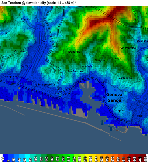
Below is the Elevation map of San Teodoro, which displays elevation range with different colors. Scale of the first map is from -14 to 488 m (-46 to 1601 ft) with average elevation of 102.1 meters (=335 ft) [note 1]
These maps also provides idea of topography and contour of this city, they are displayed at different zoom levels. More info about maps, scale and edge coordinates you can find below images.
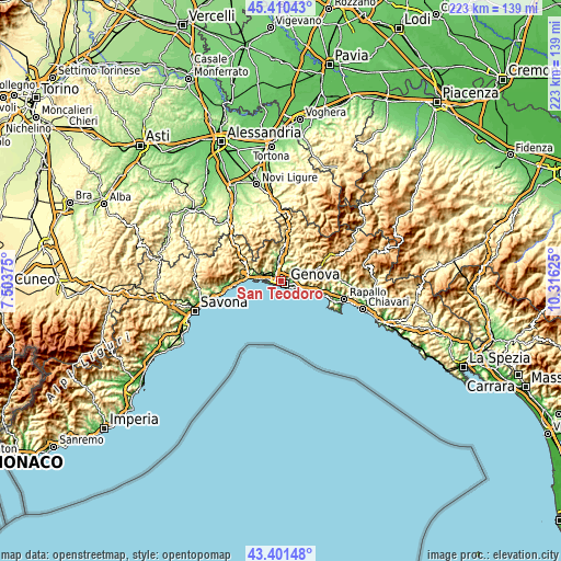
| \ | Map #1 | Topo.Map |
| Scale [m] | -14..488 m | × |
| Scale [ft] | -46..1601 ft | × |
| Average | 102.1 m = 335 ft | × |
| Width | 6.98 km = 4.3 mi | 223.4 km = 138.8 mi |
| Height | 6.98 km = 4.3 mi | 223.4 km = 138.8 mi |
| ↑Max Latitude | 44.445961° | 45.41043° |
| Latitude at center | 44.41458° | 44.41458° |
| ↓Min Latitude | 44.383182° | 43.40148° |
| ← Min Longitude | 8.866055° | 7.50375° |
| Longitude center | 8.91° | 8.91° |
| →Max Longitude | 8.953945° | 10.31625° |
Nearby cities:
Cities around San Teodoro sort by population:
• Genoa elevation 17 m
2.9 km,  111°
111°
• Serra Riccò 145 m
10.9 km,  11°
11°
• Pedemonte 128 m
9.9 km, 7°
• Campomorone 134 m
10.7 km,  349°
349°
• Ceranesi 120 m
10.2 km, 352°
• Bogliasco 40 m
13.2 km, 106°
• Manesseno 122 m
7.2 km, 11°
• Mele 126 m
13.3 km,  285°
285°
• Mignanego 176 m
12.6 km,  1°
1°
• Isoverde 235 m
13.4 km,  342°
342°
• Piccarello 173 m
8.9 km,  29°
29°
• Santa Marta 120 m
10 km, 352°
Multilingual:
 En español:
San Teodoro elevación 25 m.
 En France:
San Teodoro élévation 25 m.
 Auf Deutsch:
San Teodoro höhe über dem Meeresspiegel ist 25 m.

Sources and notes:
- [note 1] Map square and city borders are not equal. Map elevation data is calculated only from area inside that square.
- [src 1] Elevation data from geonames database provided with same terms of usage.
- [src 2] The elevation map of San Teodoro is generated using elevation data from NASA's 3 arcsec (90m) resolution SRTM data.
- [src 3] Base (background) map © OpenStreetMap contributors tiles are generated by Geofabrik and OpenTopoMap.
Copyright & License:
This San Teodoro Elevation Map is licensed under CC BY-SA. You may reuse any part from this page, if you give a proper credit by linking to this URL:
 More info on terms of use page.